Calenberg Uplands
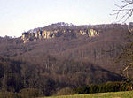
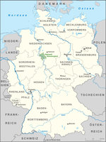
The Calenberg Uplands (German: Calenberger Bergland) are a landscape unit in the Weser-Leine Uplands in Lower Saxony, Germany. They border on the Calenberg Land to the north and merge into the Weser Uplands in the west and the Leine Uplands in the east. They are dissected by the Deister-Süntel and Aue valleys. The following ridges belong to the Calenberg Uplands: Bückeberg – 367 m above sea level (NN) Deister – 405 m above NN Harrl – 211 m above NN Kleiner Deister (L) – 346 m above NN Nesselberg (L) – 378 m above NN Osterwald (L) – 419 m above NN Süntel (W) – 437 m above NN Wesergebirge (W) – 340 m above NNWhilst the southwestern ridges of the Süntel and Weser Hills also belong to the Weser Uplands (W), the eastern heights of the Osterwald, Nesselberg and Kleiner Deister are grouped with the Leine Uplands (L).
Excerpt from the Wikipedia article Calenberg Uplands (License: CC BY-SA 3.0, Authors).Calenberg Uplands
L 439, Auetal
Geographical coordinates (GPS) Address Nearby Places Show on map
Geographical coordinates (GPS)
| Latitude | Longitude |
|---|---|
| N 52.25 ° | E 9.3166666666667 ° |
Address
L 439
31749 Auetal
Lower Saxony, Germany
Open on Google Maps
