Malá Lhota
South Moravian Region geography stubsVillages in Blansko District

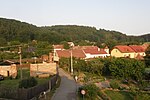
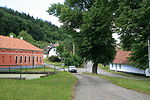
Malá Lhota is a municipality and village in Blansko District in the South Moravian Region of the Czech Republic. It has about 200 inhabitants. Malá Lhota lies approximately 8 kilometres (5 mi) west of Blansko, 22 km (14 mi) north of Brno, and 172 km (107 mi) south-east of Prague.
Excerpt from the Wikipedia article Malá Lhota (License: CC BY-SA 3.0, Authors, Images).Malá Lhota
okres Blansko
Geographical coordinates (GPS) Address Nearby Places Show on map
Geographical coordinates (GPS)
| Latitude | Longitude |
|---|---|
| N 49.391944444444 ° | E 16.549444444444 ° |
Address
17
679 21 okres Blansko
Czechia
Open on Google Maps


