place

Rancho San Pedro (Sánchez)

1839 establishments in MexicoCalifornia ranchosRanchos of San Mateo County, California

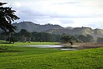
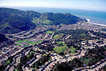
Rancho San Pedro was a 8,926-acre (36.12 km2) Mexican land grant in present-day San Mateo County, California given in 1839 by Governor Juan Alvarado to Francisco Sanchez. The grant encompasses present-day Pacifica.

Excerpt from the Wikipedia article Rancho San Pedro (Sánchez) (License: CC BY-SA 3.0, Authors).

Rancho San Pedro (Sánchez)
College Drive,

Geographical coordinates (GPS) Address Nearby Places
placeShow on map

Wikipedia: Rancho San Pedro (Sánchez)Continue reading on Wikipedia

Geographical coordinates (GPS)

Latitude Longitude
N 37.63 ° E -122.47 °
placeShow on map

Address

Skyline College

College Drive 3300
94066
California, United States
mapOpen on Google Maps

Share experience

Nearby Places

Flying Tiger Line Flight 282

Flying Tiger Line Flight 282 refers to the crash of a Lockheed Super Constellation aircraft, N6915C, shortly after takeoff from San Francisco International Airport in the early morning hours of Thursday, December 24, 1964. There were 3 crewmen aboard: pilot Jabez A. Richards, 49, of Bayhead, New Jersey; Daniel W. Hennessy, 33, of Hillsborough, California, as co-pilot, and Paul M. Entz, 37, of North Hollywood, California, as flight engineer. On Wednesday, December 23, 1964, Flying Tiger Line Flight 282 arrived at San Francisco International Airport from Japan. Filled with a cargo of electronic equipment, bolts of fabric, women's scarves, bandannas, purses, and costume jewelry for the Christmas holiday, the craft was refueled and then departed just after midnight with a crew of three, 41,000 pounds (19,000 kg) of cargo, 136 pounds (62 kg) of mail, and 5,000 gallons of high-octane aviation fuel. The weather was heavy fog and rain. A large cold front was moving onshore; it had already caused the loss of a Coast Guard helicopter.Going northwest from San Francisco Bay, Flight 282 was to head out over the ocean to circle and gain altitude, then travel east toward its destination of JFK International Airport in New York City. Shortly after takeoff, however, the plane veered to the left of its planned course. The pilot subsequently asked the tower for permission to change his radio setting from takeoff to departure frequency. Seconds later, the plane vanished from the tower's radar scope. The "Super Connie" crashed near the top of Sweeney Ridge in San Bruno, very close to the site of a Coast Guard radio station. All three crew members aboard were killed. No one on the ground was killed or injured. The Civil Aeronautics Board determined that the probable cause of the accident was that the pilot, for undetermined reasons, deviated from departure course into an area of rising terrain, where downdraft activity and turbulence affected the ability of the craft to climb.

San Francisco Bay Discovery Site

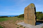
The San Francisco Bay Discovery Site is a marker commemorating the first recorded European sighting of San Francisco Bay. In 1769, the Portola expedition traveled north by land from San Diego, seeking to establish a base at the Port of Monterey described by Sebastian Vizcaino in 1602. When they reached Monterey, however, they were not sure it was the right place and decided to continue north. The party reached San Pedro Creek on October 31 and camped there for four nights, while scouts led by José Francisco Ortega climbed Sweeney Ridge, where they could see over the ridge toward the east, and so became the first Europeans to see San Francisco Bay on November 1. The scouts returned on November 3, and led the entire party up to the ridge on November 4. Franciscan missionary Juan Crespi noted in his diary, "from the summit of a peak we beheld the great estuary or arm of the sea." After seeing the immense bay to the east, and having learned from the scouts that further progress to the north would be blocked by the Golden Gate, the party turned southeast and descended toward the bay. Sweeney Ridge is located in northern San Mateo County and is now a part of the Golden Gate National Recreation Area. The site is both a California Historical Landmark and a National Historic Landmark. The spot chosen for the marker is somewhat arbitrary, as the precise location where Portola's party reached the summit of the ridge is not known. The landmarked area encompasses two of the highest knolls on the ridge.As of October, 2020, the marker has been vandalized, with Portolà’s name and the date of the discovery chiseled away.