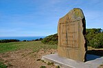
Sweeney Ridge
Bay Area Ridge TrailGolden Gate National Recreation AreaLandforms of San Mateo County, CaliforniaPacifica, CaliforniaParks in San Mateo County, California ... and 3 more
Raptor migration sitesRidges of CaliforniaSan Mateo County, California geography stubs

Sweeney Ridge, is a 1,200-acre (5 km2) hilly hiking area of ridges and ravines between San Bruno and Pacifica, California, about a 25-minute drive south from San Francisco. The ridge's 1,200-foot-high summit, covered with coastal scrub and grassland, slopes down to San Francisco Bay on the east and to the Pacific Ocean on the west. The ridge is part of the Golden Gate National Recreation Area. Historically, the ridge is the location of the San Francisco Bay Discovery Site, commemorating the Portolá expedition's first sighting of San Francisco Bay on November 4, 1769 (expedition scouts actually made the discovery a few days earlier).
Excerpt from the Wikipedia article Sweeney Ridge (License: CC BY-SA 3.0, Authors, Images).Sweeney Ridge
Sneath Lane Trail,
Geographical coordinates (GPS) Address Nearby Places Show on map
Geographical coordinates (GPS)
| Latitude | Longitude |
|---|---|
| N 37.608 ° | E -122.457 ° |
Address
Sneath Lane Trail
Sneath Lane Trail
94066
California, United States
Open on Google Maps


