Eastville, Bristol
Areas of BristolCommons category link is locally definedEngvarB from October 2013Wards of Bristol

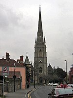
Eastville is the name of both a council ward in the city of Bristol in the United Kingdom and a suburb of the city that lies within that ward. The Eastville ward covers the areas of Eastville, Crofts End (also known as Clay Hill), Stapleton and part of Fishponds. Notable places within the ward include Bristol Metropolitan Academy ( formerly Whitefield Fishponds Community School) and Colston's School, and the Bristol and Bath Railway Path also passes through the ward.
Excerpt from the Wikipedia article Eastville, Bristol (License: CC BY-SA 3.0, Authors, Images).Eastville, Bristol
Muller Road, Bristol Eastville
Geographical coordinates (GPS) Address Nearby Places Show on map
Geographical coordinates (GPS)
| Latitude | Longitude |
|---|---|
| N 51.475 ° | E -2.5574 ° |
Address
Muller Road
Muller Road
BS5 6XA Bristol, Eastville
England, United Kingdom
Open on Google Maps


