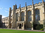
Magdalene Street
History of CambridgeMagdalene College, CambridgeSt John's College, CambridgeStreets in CambridgeUse British English from March 2018

Magdalene Street is a street in the north of central Cambridge, England. It runs between Castle Street, by Castle Hill, at the junction with Northampton Street and Chesterton Lane, then Chesterton Road (the A1303), to the northwest and Bridge Street at the junction with Thompson's Lane to the southeast.The road straddles the River Cam on Magdalene Bridge (built 1823), just south of Magdalene College (hence the name) and just north of St John's College, one of the largest University of Cambridge colleges. Magdalene Bridge or the Great Bridge is on the site of the original bridge that gave 'Cambridge' its name.
Excerpt from the Wikipedia article Magdalene Street (License: CC BY-SA 3.0, Authors, Images).Magdalene Street
Bridge Street, Cambridge Petersfield
Geographical coordinates (GPS) Address Website Nearby Places Show on map
Geographical coordinates (GPS)
| Latitude | Longitude |
|---|---|
| N 52.2097 ° | E 0.1166 ° |
Address
Galleria
Bridge Street 33
CB2 1UW Cambridge, Petersfield
England, United Kingdom
Open on Google Maps


