Auderghem

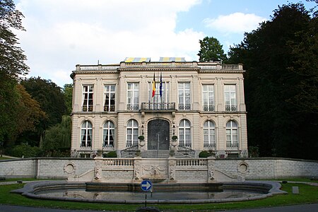
Auderghem (former Dutch spelling, now used in French; pronounced [odəʁɡɛm]) or Oudergem (Dutch: [ˈʌudərɣɛm] (listen)) is one of the 19 municipalities of the Brussels-Capital Region (Belgium). Located to the southeast of the region, along the Woluwe valley and at the entrance to the Sonian Forest (French: Forêt de Soignes, Dutch: Zoniënwoud), the municipality has an environmental advantage. Despite large roads slicing through and the increasing traffic, it has been able to preserve a relatively important part of its natural and historic legacy: the creeks, the Red Cloister Abbey and its art centre, the Priory of Val-Duchesse, the Château of Three Fountains (French: Trois Fontaines, Dutch: Drie Fonteinen), the Château of Saint Anne, and the remarkable Chapel of Saint Anne. Auderghem is adjacent to the municipalities of Etterbeek, Ixelles, Woluwe-Saint-Pierre, and Watermael-Boitsfort. In common with all of Brussels’ municipalities, it is legally bilingual (French–Dutch). The municipality is governed by its 16th mayor, Didier Gosuin (FDF).
Excerpt from the Wikipedia article Auderghem (License: CC BY-SA 3.0, Authors, Images).Auderghem
Boulevard du Souverain - Vorstlaan,
Geographical coordinates (GPS) Address Nearby Places Show on map
Geographical coordinates (GPS)
| Latitude | Longitude |
|---|---|
| N 50.816666666667 ° | E 4.4261111111111 ° |
Address
Boulevard du Souverain - Vorstlaan 278
1160
Belgium
Open on Google Maps


