place

Rye Meads

East Hertfordshire DistrictHerts and Middlesex Wildlife Trust reservesHoddesdonLee Valley ParkMeadows in Hertfordshire
Nature reserves in HertfordshireRoyal Society for the Protection of Birds reserves in EnglandSites of Special Scientific Interest in HertfordshireUse British English from June 2015
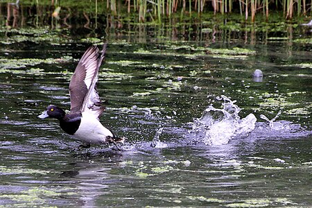
Aythya fuligula (5800456581)

Rye Meads is a 58.5-hectare (145-acre) biological Site of Special Scientific Interest (SSSI) in Rye House, Hoddesdon, Hertfordshire. It is one of series of wetlands and reservoirs situated along the River Lea, to the north-east of London. It is part of the Lea Valley Ramsar site (a group of internationally important wetland sites) and a Special Protection Area. The SSSI is divided into three areas. North of Rye Road is the Rye Meads nature reserve, which is open to the public. The western half of this nature reserve, next to the River Lea in the Lee Valley Regional Park, is managed by the Royal Society for the Protection of Birds (RSPB). The eastern half is managed by the Hertfordshire and Middlesex Wildlife Trust (HMWT). The SSSI also includes a meadow and lagoons owned by Thames Water south of Rye Road which is not open to the public.The RSPB reserve has ten birdwatching hides, trails and a visitor centre. Birds include kingfisher, snipe, green sandpiper, shoveler, gadwall and tufted duck.The HMWT site is an ancient flood meadow which has a variety of habitats including reedbed, marshy grassland and fen. It is grazed by ponies and water buffalo.The entrance to the nature reserve is on Rye Road. There is a path around the site, but a one-way turnstile blocks wheelchairs and pushchairs, and only allows access from the RSPB half to the HMWT area, not vice versa.

Excerpt from the Wikipedia article Rye Meads (License: CC BY-SA 3.0, Authors, Images).

Rye Meads
Kingfisher Trail, East Hertfordshire Stanstead Abbots

Geographical coordinates (GPS) Address External links Nearby Places
placeShow on map

Wikipedia: Rye MeadsContinue reading on Wikipedia

Geographical coordinates (GPS)

Latitude Longitude
N 51.776 ° E 0.0061 °
placeShow on map

Address

Rye Meads

Kingfisher Trail
EN11 0QH East Hertfordshire, Stanstead Abbots
England, United Kingdom
mapOpen on Google Maps

linkWikiData (Q7384977)
linkOpenStreetMap (8046078)

Aythya fuligula (5800456581)
Share experience

Nearby Places

The John Warner School

The John Warner School is a secondary school with academy status for 11- to 18-year-olds in Hoddesdon, Hertfordshire, England. It is located on Stanstead Road opposite the Hundred Acre Estate and is backed by the New River.Established in 1953 as Hoddesdon Secondary School, it adopted the name John Warner in 1968, after the man who established the first all-boys school for all classes and any religious beliefs in 1841.The school has many facilities, including its sport centre which opened in 2001, (consisting of a swimming pool, several astro-turf pitches, sports hall and many other facilities), which is available for use by all students of the school, and also a newly built science block which was added in 2005, that aided the school in gaining the status of a Science College. Many local primary schools in the area have science lessons in the school's new laboratories. Also the school has specialist technology status. On the 1 April 2011, The John Warner School was reformed to Academy status.The school participates in many extra-curricular activities, and events, including Model United Nations, and the Vex Robotics Competition. It has also begun hosting its own MUN conferences. The school is undergoing renovation to improve the experience of the pupils, with multiple new blocks being built, starting with a new Modern Foreign Languages block, an Engineering & DT block, a new Library and temporary Mathematics department, and as of May 2016 a new Mathematics block is being built.