place

Pastures Historic District

Buildings and structures in Albany, New YorkHistoric districts in Albany County, New YorkHistoric districts on the National Register of Historic Places in New York (state)NRHP infobox with nocatNational Register of Historic Places in Albany, New York
Neighborhoods in Albany, New York
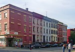
Houses on Westerlo Street, Albany, NY

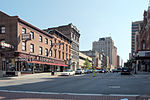
The Pastures Historic District is a residential neighborhood located south of downtown Albany, New York, United States. Its 17 acres (6.9 ha) include all or part of a 13-block area. It was originally an area set aside as communal pasture by Albany's city council in the late 17th century and deeded to the Dutch Reformed Church. As the city began to grow following its designation as New York's state capital a century later, it was subdivided into building lots, some of which were developed with small rowhouses. Many open areas remain today, and the houses have not been significantly altered. In 1972 the city designated it as a historic district and it was listed on the National Register of Historic Places. All but two buildings in the district are considered historic. One of Albany's busiest neighborhoods in the 19th century, the area fell into decline during the third quarter of the 20th as citizens left the city for the suburbs. Instead of the wholesale demolition of that era's urban renewal programs, the city government attempted to preserve and revitalize the area, evacuating the residents for years and demolishing some properties, a move that has been criticized as destroying the neighborhood as a standard urban renewal project would have. A recent mortgage fraud scandal has affected the neighborhood also, but it has once again become a diverse, fully occupied neighborhood.

Excerpt from the Wikipedia article Pastures Historic District (License: CC BY-SA 3.0, Authors, Images).

Pastures Historic District
Westerlo Street, City of Albany

Geographical coordinates (GPS) Address Nearby Places
placeShow on map

Wikipedia: Pastures Historic DistrictContinue reading on Wikipedia

Geographical coordinates (GPS)

Latitude Longitude
N 42.643611111111 ° E -73.754166666667 °
placeShow on map

Address

Westerlo Street 51
12202 City of Albany
New York, United States
mapOpen on Google Maps

Houses on Westerlo Street, Albany, NY
Share experience

Nearby Places

Albany Free School

The Free School is the oldest independent, inner-city alternative school in the United States. Founded by Mary Leue in 1969 based on the English Summerhill School philosophy, the free school lets students learn at their own pace. It has no grades, tests, or firm schedule: students design their own daily plans for learning. The school is self-governed through a weekly, democratic all-school meeting run by students in Robert's Rules. Students and staff alike receive one equal vote apiece. Unlike Summerhill-style schools, the Free School is a day school that serves predominantly working-class children. Nearly 80 percent of the school is eligible for reduced-price meals in the public schools. About 60 students between the ages of three and fourteen attend, and are staffed by six full-time teachers and a number of volunteers. The school runs on a shoestring budget as a tradeoff for its financial independence and accessibility to low-income students. Tuition is billed on a sliding scale based on what parents can afford. Revenue from rental properties and fundraising supplements tuition income. The Free School started a high school program in 2006 that later spun off as the Harriet Tubman Democratic High School before closing in 2017. Journalists have likened the school's approach to unschooling and homeschooling, and its work to that of prefigurative politics. The Albany Free School is one of the few schools remaining from the 1960s and 1970s free school movement. It inspired the program of the Brooklyn Free School.

Knickerbocker and Arnink Garages

The Knickerbocker and Arnink Garages were two attached stone buildings located on Hudson Avenue in central Albany, New York, United States. Both were built in the early 20th century; the Knickerbocker garage was added to the Arnink garage 12 years after it was built. In 1980, they were listed on the National Register of Historic Places; nine years later they were both demolished and delisted. At the time, many garages were adapted from stables or carriage houses. The first to be built, the smaller, was instead adapted from an existing commercial building by the owner of a successful Ford dealership in the city for his car-rental and repair service. His superintendent later bought the business from him and had the larger one built in the same style by the same architect. They were among the earliest structures in Albany built specifically in response to the increasing use of the automobile at that time. Their neo-Gothic cast stone facades are an unusual choice of style and material for that time. They may have been inspired by the nearby Delaware and Hudson Railroad office building, a contemporary catalyst for the redevelopment of downtown that is today the system administration building for the State University of New York. One was later converted into a warehouse and used for that purpose until its demolition. That came about as part of a plan for two large office towers proposed for the neighborhood as redevelopment. Nothing has been built on the space since; it is used as part of a parking lot that serves another nearby redevelopment project, the Times Union Center.

Downtown Albany Historic District

The Downtown Albany Historic District is a 19-block, 66.6-acre (27.0 ha) area of Albany, New York, United States, centered on the junction of State (New York State Route 5) and North and South Pearl streets (New York State Route 32). It is the oldest settled area of the city, originally planned and settled in the 17th century, and the nucleus of its later development and expansion. In 1980 it was designated a historic district by the city and then listed on the National Register of Historic Places.Its 164 buildings are a mix of tall commercial buildings on the main streets and small houses on the side. Most were built between 1880 and 1930, the district's period of significance, with some dating to the 1810s. All major streets have a major building as their focal point. Several contributing properties have been listed on the Register in their own right, and one designated a National Historic Landmark. Albany's earliest skyscrapers were built here, including one that was the city's tallest at the time of its completion. The current mix of buildings reflects the city's peak of industrial prosperity in the Gilded Age, with many built by banks, as well as the city's status as New York's state capital. It has been displaced in the city's skyline by later construction, particularly by the Empire State Plaza, the modernist home of New York's state government. Urban renewal programs of the late 20th century largely bypassed the district for political reasons. As a result, its historic buildings are mostly intact, although some have been compromised through neglect. In 2022 the state proposed some changes that would add some more modern buildings as contributing properties. The amended boundaries were accepted that May.