place

Arlington station (NJ Transit)
1873 establishments in New Jersey2002 disestablishments in New JerseyDemolished railway stations in the United StatesFormer Erie Railroad stationsFormer NJ Transit stations
Former railway stations in New JerseyKearny, New JerseyNew Jersey railway station stubsRailway stations closed in 2002Railway stations in the United States closed in the 2000sRailway stations in the United States opened in 1873Use mdy dates from June 2012
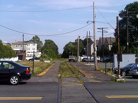
Arlington station site, 2010

Arlington is a former commuter railroad train station in the Arlington section of Kearny, Hudson County, New Jersey. Located on Garafola Place between the Forest and Elm Street intersections, the station served trains on NJ Transit's Boonton Line as well as the only remaining active station in Kearny until its closure. The station, which contained two low-level side platforms, operated trains between Hoboken Terminal and locations west to Dover and Hackettstown. The next station to the east was Hoboken while the station to the west was Rowe Street in Bloomfield. Railroad service through the Arlington neighborhood began on January 1, 1873 with the introduction of the Montclair Railway between Pavonia Terminal in Jersey City to Monks in West Milford. The station was one of two in Kearny for the line, with the other one at West Arlington. This line became and the New York and Greenwood Lake Railroad, operated by the Erie Railroad until October 17, 1960. The line became part of the merged Greenwood Lake-Boonton Line in 1963. The service continued into NJ Transit, becoming the Boonton Line. Arlington station closed, along with Rowe Street and Benson Street station in Glen Ridge on September 20, 2002 in advance of the opening of the Montclair Connection.

Excerpt from the Wikipedia article Arlington station (NJ Transit) (License: CC BY-SA 3.0, Authors, Images).

Arlington station (NJ Transit)
Garafola Place,

Geographical coordinates (GPS) Address Nearby Places
placeShow on map

Wikipedia: Arlington station (NJ Transit)Continue reading on Wikipedia

Geographical coordinates (GPS)

Latitude Longitude
N 40.7698 ° E -74.1401 °
placeShow on map

Address

Garafola Place

Garafola Place
07032
New Jersey, United States
mapOpen on Google Maps

Arlington station site, 2010
Share experience

Nearby Places

West Hudson, New Jersey

West Hudson is the western part of Hudson County, New Jersey comprising the contiguous municipalities of Kearny, Harrison and East Newark, which lies on the peninsula between the Hackensack River and Passaic River.The Passaic River separates it from Newark and Belleville, and the Hackensack River separates it from Jersey City, the county seat, and Secaucus. Residential and commercial districts, including Arlington, are concentrated along the banks of the Passaic, also site of Kearny Riverbank Park. At Kearny Point there is more industry. Brownfields or protected areas known as the Kearny Meadows or the Kearny Marsh are part of the New Jersey Meadowlands. West Hudson Park is the county park in the area. Arlington Memorial Park cemetery is located on Schuyler Avenue.The area was known as Meghgectecock (spellings include masgichteu-cunk) by the Hackensack tribe of Lenape people who lived there at the time of European colonization, meaning where May-apples grow, from a moist-woodland perennial that bears edible yellow berries and used to describe the lobe of land between and before the confluence of the Hackensack and Passaic at Newark Bay. During the 17th century was part of the area called Achter Col by New Netherlanders in the province of New Netherland. It was later given the name New Barbadoes Neck by British colonialists. All of West Hudson was originally part of Essex County under the jurisdiction of Newark. In 1710 it was made part of New Barbadoes Township, and part of Bergen County. The West Hudson municipalities were part of Harrison Township, which was created by an act of the New Jersey Legislature on April 13, 1840, and was part of Hudson County, which had been created from portions of Bergen County on February 22, 1840. The current borders were created through a series of secessions and reincorporations.The West Hudson towns and Newark, particularly the Ironbound across the Passaic, have had a long tradition of soccer. Kearny's nickname, "Soccer Town, USA" comes from tradition that originated in the mid-1870s, when thousands of Scottish and Irish immigrants settled there after two Scottish companies, Clark Thread Company and Nairn Linoleum, opened. The Newark Portuguese, Clark A.A., Harrison S.C. and West Hudson A.A. were among the many teams. The Red Bulls Stadium is in Harrison. Portion of the Morris Canal ran through Kearny Point, unused portions which remain today. The peninsula is crisscrossed with rail passenger and freight rail lines, including those of Amtrak, New Jersey Transit, and PATH, the last of which maintains a station at Harrison (Amtrak and NJT having ceased service there). Also in this area was the former Manhattan Transfer. The Kearny Connection and Waterfront Connection are major passenger rail junctions. The proposed high-speed rail line known as the Gateway Project will traverse the area and includes the replacement of the Portal Bridge and the Sawtooth Bridges. West Hudson's Saint Patrick's Day Parade passes through the three municipalities.Since the creation of the 29th Legislative District in the 1970s, the three communities have always been represented in the same district.