place

St Giles' Church, Wrexham

Church in Wales church buildings in Wrexham County BoroughGrade I listed churches in Wrexham County BoroughLandmarks in WalesMajor Churches NetworkTourist attractions in Wrexham County Borough
Wrexham
Stgileswrexham
Stgileswrexham

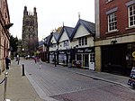
St Giles' Parish Church (Welsh: Eglwys San Silyn) is the parish church of Wrexham, Wales. The church is recognised as one of the finest examples of ecclesiastical architecture in Wales and is a Grade I listed building, described by Sir Simon Jenkins as 'the glory of the Marches' and by W. D. Caröe as a “glorious masterpiece.”The iconic 16th-century tower rises to a height of 41 m (136 feet) and is a local landmark that can be seen for many miles around. It forms one of the 'Seven Wonders of Wales'. St Giles' occupies a site of continuous Christian worship for at least 800 years. The main body of the current church was built at the end of the 15th century and beginning of the 16th centuries. It is widely held to be among the greatest of the medieval buildings still standing in Wales.The church contains numerous works of note including decorative carvings and statuary dating from the 14th century, monuments by Roubiliac and Woolner, a stained-glass window attributed to Burne-Jones and one of the oldest brass eagle lecterns in Britain.The tomb of Elihu Yale, benefactor of Yale University in New Haven, Connecticut, is located in the churchyard. In recognition of this connection, 'Wrexham Tower' of Saybrook College in the university was modelled on the tower of St Giles'.

Excerpt from the Wikipedia article St Giles' Church, Wrexham (License: CC BY-SA 3.0, Authors, Images).

St Giles' Church, Wrexham
Temple Row, Wrexham Hightown

Geographical coordinates (GPS) Address External links Nearby Places
placeShow on map

Wikipedia: St Giles' Church, WrexhamContinue reading on Wikipedia

Geographical coordinates (GPS)

Latitude Longitude
N 53.0442 ° E -2.9927 °
placeShow on map

Address

St Giles Parish Church

Temple Row
LL13 7AA Wrexham, Hightown
Wales, United Kingdom
mapOpen on Google Maps

linkWikiData (Q7593267)
linkOpenStreetMap (48285923)

Stgileswrexham
Stgileswrexham
Share experience

Nearby Places

Wrexham
Wrexham

Wrexham ( REK-səm; Welsh: Wrecsam [ˈrɛksam]) is a city and the administrative centre of Wrexham County Borough in Wales. It is located between the Welsh mountains and the lower Dee Valley, near the border with Cheshire in England. Historically in the county of Denbighshire, and later the county of Clwyd in 1974, it has been the principal settlement of Wrexham County Borough since 1996. Wrexham has historically been one of the primary settlements of Wales. At the 2021 Census, it had an urban population of 44,785. The core of the city comprises the local government communities of Acton, Caia Park, Offa and Rhosddu. In the 2011 census, Wrexham's built-up area was determined to extend further into villages like Brymbo, Brynteg, Gwersyllt, New Broughton and Pentre Broughton with a population of 61,603, while also including nearby Bradley and Rhostyllen for a population of 65,692 in 2011.Wrexham was likely founded prior to the 11th century and developed in the Middle Ages as a regional centre for trade and administration. The city became the most populous settlement in Wales in the 17th century and was at the forefront of the Industrial Revolution from the 18th century. Prior to de-industrialisation in the 20th century, the city and surrounding area were a hub of coal and lead mining; the production of iron, steel and leather; and brewing.Today, Wrexham continues to serve north Wales and the Welsh borderlands as a centre for manufacturing, retail, education and administration. The city is noted for hosting Wrexham A.F.C. (one of the oldest professional football teams in the world); the nationally significant industrial heritage of the Clywedog Valley; the National Trust Property of Erddig; and the fine Tudor church of St Giles, which towers over the historic Wrexham city centre.