place

Battant (Besançon)

Areas of Besançon
Battant Besançon
Battant Besançon

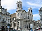
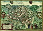
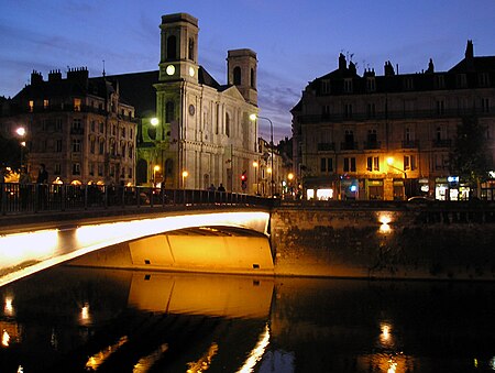
Battant is one of the oldest parts of Besançon, Doubs, France, and has been under architectural protection since 1964. It is situated on the right bank of the river Doubs, north of the ox-bow that encircles the center of the city. A bridge across the Doubs joins the two quarters Battant and La Boucle (The Oxbow), via the Vauban quay and Jouffroy d'Abbans Place. Today, Battant has become a popular district with a diverse population, numbering about 4,200 people. It is one of the more lively quarters of the city because of its numerous small shops, its nightlife, and its market. The quarter's name appears to have come from the Mouillère, a small brook also known as the fons batenti (river of the beater) because the water from the brook drove a cloth-beating device. The name came to be applied to a nearby street, and then by extension to the entire quarter. The inhabitants of Battant are known as Bousbots, which recalls the resistance that the grape growers of the district gave to the attempted seizure of the city by the Huguenots of Montbéliard on the night of 20–21 June 1575.

Excerpt from the Wikipedia article Battant (Besançon) (License: CC BY-SA 3.0, Authors, Images).

Battant (Besançon)
Rue de la Madeleine, Besançon Rue Battant

Geographical coordinates (GPS) Address Nearby Places
placeShow on map

Wikipedia: Battant (Besançon)Continue reading on Wikipedia

Geographical coordinates (GPS)

Latitude Longitude
N 47.240555555556 ° E 6.0194444444444 °
placeShow on map

Address

Intervista RH

Rue de la Madeleine
25000 Besançon, Rue Battant
Bourgogne-Franche-Comté, France
mapOpen on Google Maps

Battant Besançon
Battant Besançon
Share experience

Nearby Places

Besançon
Besançon

Besançon (UK: , US: , French: [bəzɑ̃sɔ̃] , Franco-Provençal: [bəzɑ̃ˈsɔ̃]; archaic German: Bisanz; Latin: Vesontio) is the prefecture of the department of Doubs in the region of Bourgogne-Franche-Comté. The city is located in Eastern France, close to the Jura Mountains and the border with Switzerland. Capital of the historic and cultural region of Franche-Comté, Besançon is home to the Bourgogne-Franche-Comté regional council headquarters, and is an important administrative centre in the region. It is also the seat of one of the fifteen French ecclesiastical provinces and one of the two divisions of the French Army. In 2020 the city had a population of 118,258, in a metropolitan area of 281,610, the second in the region in terms of population. Established in a meander of the river Doubs, the city was already important during the Gallo-Roman era under the name of Vesontio, capital of the Sequani. Its geography and specific history turned it into a military stronghold, a garrison city, a political centre, and a religious capital. Besançon is the historical capital of watchmaking in France. This has led it to become a centre for innovative companies in the fields of microtechnology, micromechanics, and biomedical engineering. The University of Franche-Comté, founded in 1423, enrolls nearly 30,000 students each year, including around 4,000 trainees from all over the world within its Centre for Applied Linguistics (CLA). The greenest city in France, it enjoys a quality of life recognized in Europe. Thanks to its rich historical and cultural heritage and its unique architecture, Besançon has been labeled a "Town of Art and History" since 1986. Its fortifications, designed by Vauban, have been listed as a UNESCO World Heritage Site since 2008.

Francia
Francia

The Kingdom of the Franks (Latin: Regnum Francorum), also known as the Frankish Kingdom, the Frankish Empire (Latin: Imperium Francorum) or Francia, was the largest post-Roman barbarian kingdom in Western Europe. It was ruled by the Frankish Merovingian and Carolingian dynasties during the Early Middle Ages. Francia was among the last surviving Germanic kingdoms from the Migration Period era. The original core Frankish territories inside the former Western Roman Empire were close to the Rhine and Meuse rivers in the north, but Franks such as Chlodio and Childeric I expanded Frankish rule into what is now northern France. A single kingdom uniting all Franks was founded by Clovis I, the son of Childeric, who was crowned King of the Franks in 496. He founded the Merovingian dynasty, which was eventually replaced by the Carolingian dynasty. Under the nearly continuous campaigns of Pepin of Herstal, Charles Martel, Pepin the Short, Charlemagne, and Louis the Pious—father, son, grandson, great-grandson and great-great-grandson—the greatest expansion of the Frankish empire was secured by the early 9th century, and is by this point referred to as the Carolingian Empire. During the Merovingian and Carolingian dynasties the Frankish realm was one large polity, generally subdivided into several smaller kingdoms ruled by different members of the ruling dynasties. These coordinated but also regularly came into conflict with each other. The old Frankish lands, for example, were initially contained within the kingdom of Austrasia, centred on the Rhine and Meuse, roughly corresponding to later Lower Lotharingia. The Gallo-Roman territory to its south and west was called Neustria. The exact borders and number of these subkingdoms varied over time, until a basic split between eastern and western domains became persistent. After various treaties and conflicts in the late-9th and early-10th centuries, West Francia continued as the medieval Kingdom of France, while East Francia and Lotharingia came under the control of the non-Frankish Ottonian dynasty, and became the core of the medieval Holy Roman Empire.