Whinburgh and Westfield

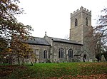
Whinburgh and Westfield is a civil parish in the English county of Norfolk. It covers an area of 7.56 km2 (2.92 sq mi) and had a population of 307 in 134 households at the 2001 census. 10 years later it has a population (including Brakefield Green) of 342 according to the 2011 census. For the purposes of local government, it falls within the district of Breckland. The civil parish is located south of the nearby town Dereham and is formed from the two ancient parishes which centred round the churches of St Mary's Whinburgh and St Andrew's Westfield, and until 1894 the churches performed all the functions of local government. Norfolk was a county of small villages and parishes. The County of Norfolk Review Order, 1935, sought to rationalise this, and under this Westfield Parish was 'abolished' and merged with Whinburgh Parish. The name of the resultant parish was not changed from Whinburgh. For many years nothing was done about the parish's name, but on 2 August 1995, at the request of the Parish Council, Breckland Council sealed a 'Notice of the Change of Parish Name' and the parish then became Whinburgh and Westfield.
Excerpt from the Wikipedia article Whinburgh and Westfield (License: CC BY-SA 3.0, Authors, Images).Whinburgh and Westfield
Dereham Road, Breckland District Whinburgh and Westfield
Geographical coordinates (GPS) Address Nearby Places Show on map
Geographical coordinates (GPS)
| Latitude | Longitude |
|---|---|
| N 52.64379 ° | E 0.96783 ° |
Address
Dereham Road
Dereham Road
NR19 1AA Breckland District, Whinburgh and Westfield
England, United Kingdom
Open on Google Maps


