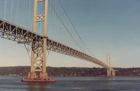
Tacoma Narrows Bridge (1950)

The 1950 Tacoma Narrows Bridge is a suspension bridge in the U.S. state of Washington that carries the westbound lanes of Washington State Route 16 (known as Primary State Highway 14 until 1964) across the Tacoma Narrows strait, between the city of Tacoma and the Kitsap Peninsula. Opened on October 14, 1950, it was built in the same location as the original Tacoma Narrows Bridge, which collapsed due to a windstorm on November 7, 1940. It is the older of the twin bridges that make up the Tacoma Narrows Bridge crossing of the Tacoma Narrows, and carried both directions of traffic across the strait until 2007. At the time of its construction, the bridge was, like its predecessor, the third-longest suspension bridge in the world in terms of main span length, behind the Golden Gate Bridge and George Washington Bridge; it is now the 46th longest suspension bridge in the world. Design work on a new Tacoma Narrows Bridge began shortly after the collapse of the original bridge. However, several engineering issues, the demand on steel created by the United States' involvement in World War II, and the state of Washington's inability to find an insurer, all pushed the start of construction to April 1948. The new bridge was designed with a wider deck and taller and wider towers than its predecessor, and addressed the wind issues that led to the original bridge's collapse. It opened to the public on October 14, 1950, and carried both directions of Primary State Highway 14 for over 40 years. Tolls were charged on the bridge until 1965, when the bonds were retired 13 years ahead of schedule. “The price tag for construction was one-third more than the Toll Bridge Authority estimated--$11.2 million. The final construction cost estimate, made just prior to the bond issue, reached $13,738,000.”By 1990, population growth and development on the Kitsap Peninsula caused vehicular traffic on the bridge to exceed its design capacity. In 1998, voters in several Washington counties approved an advisory measure to create a twin bridge to span the Tacoma Narrows. After a series of protests and court battles, construction began on the second span in 2002. The second span opened in July 2007 to carry eastbound traffic, and the 1950 bridge was reconfigured to carry westbound traffic.
Excerpt from the Wikipedia article Tacoma Narrows Bridge (1950) (License: CC BY-SA 3.0, Authors, Images).Tacoma Narrows Bridge (1950)
WA 16,
Geographical coordinates (GPS) Address Nearby Places Show on map
Geographical coordinates (GPS)
| Latitude | Longitude |
|---|---|
| N 47.268888888889 ° | E -122.55166666667 ° |
Address
Tacoma Narrows Bridge
WA 16
98465
Washington, United States
Open on Google Maps


