Katimavik-Hazeldean
Neighbourhoods in OttawaUse Canadian English from January 2023
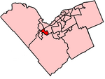
Katimavik-Hazeldean is a neighbourhood in Kanata South Ward in the west end of Ottawa, Ontario, Canada. It is located in the former City of Kanata which amalgamated into Ottawa in 2001. It is located in south-central Kanata, bounded by Eagleson Road to the east, Hazeldean Road to the south, the Carp River to the west, and Highway 417 to the north.According to the Canada 2011 Census, the total population of the neighbourhood was 12,088.
Excerpt from the Wikipedia article Katimavik-Hazeldean (License: CC BY-SA 3.0, Authors).Katimavik-Hazeldean
Kakulu Road, Ottawa Kanata
Geographical coordinates (GPS) Address Nearby Places Show on map
Geographical coordinates (GPS)
| Latitude | Longitude |
|---|---|
| N 45.305555555556 ° | E -75.891666666667 ° |
Address
Ball Diamond
Kakulu Road
K2L 1Y9 Ottawa, Kanata
Ontario, Canada
Open on Google Maps


