place

Gurney Manor

Grade I listed buildings in SedgemoorGrade I listed houses in SomersetHouses completed in the 13th centuryLandmark Trust properties in England
Gurney Manor
Gurney Manor

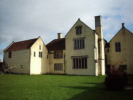
Gurney Manor in Cannington, Somerset, England is a 13th-century manor house with an attached chapel wing. It is now supported by the Landmark Trust and is available as holiday accommodation. It has been designated as a Grade I listed building and is considered notable partly due to the substantial survival of medieval construction throughout.The first building on the site was an open hall house erected before 1350. It was rebuilt around 1400 with various additions during the 15th century. William Dodisham added the south wing, porch, and kitchen and put in new windows. In 1480 he left it to his niece Agnes, who married local landowner Walter Michael. Their family and descendants owned and improved the manor until 1616. It then became a farmhouse often inhabited by tenants until the early 20th century. In these 300 years the property enjoyed few improvements but nonetheless suffered few fundamental alterations. In World War II the house was divided into flats by a Mr Harris, whose descendants sold it to the Landmark Trust in the 1980s. The interior includes the remnants of a 17th-century strapwork plaster ceiling.Restoration work in the late 20th century included the repair of structural problems as well as the construction of new oak roof trusses made in a traditional fashion with an adze.

Excerpt from the Wikipedia article Gurney Manor (License: CC BY-SA 3.0, Authors, Images).

Gurney Manor
Gurney Street,

Geographical coordinates (GPS) Address Nearby Places
placeShow on map

Wikipedia: Gurney ManorContinue reading on Wikipedia

Geographical coordinates (GPS)

Latitude Longitude
N 51.1499 ° E -3.0559 °
placeShow on map

Address

Gurney Street

Gurney Street
TA5 2HW , Cannington
England, United Kingdom
mapOpen on Google Maps

Gurney Manor
Gurney Manor
Share experience

Nearby Places

Brymore Academy
Brymore Academy

Brymore Academy (formerly Brymore School) is a boys' secondary school with academy status, located in Cannington, Bridgwater, Somerset, England. It is a day and boarding school for pupils aged 11 to 17 years and had 192 boys on the roll in 2015, 115 of them boarders. It was established in 1951 by Somerset County Council at a cost of £6,000 as a Secondary Technical School of Agriculture.The school has a farm, walled garden, greenhouses and workshops including a foundry and forge. The farm includes a dairy herd, beef animals, sows, poultry and a flock of ewes with lambs.Brymore offers extra-curricular activities including beekeeping, canoeing and cycling. The school is expanding to take in Year 7s. The school will continue to enter boys in Year 9, provided there are sufficient places available. The main school building incorporates parts of a medieval house which was owned by John Pym who, during the English Civil War played a role in bringing about the downfall of Charles I. In World War II girls of Malvern College were evacuated to Brymore. In 1943 the 535th Automatic Weapons battalion of the US Army was billeted in the house and grounds while they prepared for D-Day. The building is designated as a Grade II listed building. The boarding houses included the Grade I listed Cannington Court.The buildings and grounds of Brymore Academy are used annually during the summer break for 3 "Venture" camps called Brymore 1, 2, and 3.

Combwich
Combwich

Combwich ( KUM-ij) is a village in the parish of Otterhampton within the Sedgemoor district of Somerset, between Bridgwater and the Steart Peninsula. The village lies on Combwich Reach as the River Parrett flows to the sea and was the site of an ancient ferry crossing. In the Domesday book it was known as Comiz which means 'The settlement at the short, broad, open valley' (from Old English cumb). This is clearly a reference to the valley of exactly this topographical description, immediately to the south of the village, and through which the South Moor Brook flows westwards into the River Parrett. One derivation of -wich is thought to be from Latin 'vicus', and there are archaeological indications that there was a settlement at Combwich in the Romano-British period, based around a ferry across the Parrett at this point. The exact meaning of the second element here is uncertain at present, as Old English -wic can have a variety of meanings attributed to it.It served as a port for the export of local produce and the import of timber from the 15th century. It also served the local brick and coal yard until the creek silted up in the 1930s. Brick and tile making was first recorded in the village in 1842. As of 2019, Combwich wharf is being used for the delivery of large equipment for the building of Hinkley Point C nuclear power station.The Steart Peninsula has flooded many times during the last millennium. The most severe recent floods occurred in 1981. By 1997, a combination of coastal erosion, sea level rise and wave action had made some of the defences distinctly fragile and at risk from failure. As a result, in 2002 The Environment Agency produced the Stolford to Combwich Coastal Defence Strategy Study to examine options for the future.