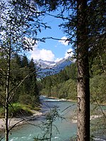
Speikboden (South Tyrol)
Mountains of South TyrolMountains of the AlpsZillertal Alps

Speikboden is a massif in the Central Eastern Alps located between the three valleys Weißenbach, Mühlwald and Ahrntal. Running in a south-easterly direction, it forms the eastern part of an outlier of the western Zillertal Alps. Its highest point, likewise named Speikboden, is 2,517 m. Further well-known peaks in this massif include Seewassernock (2,516 m), Große Nock (2,400 m), Kleine Nock (2,227 m) and Gornerberg (2,475 m). Villages in the valley include Lappach, Luttach, Mühlwald, Sand in Taufers, St. Johann and Weißenbach.
Excerpt from the Wikipedia article Speikboden (South Tyrol) (License: CC BY-SA 3.0, Authors, Images).Speikboden (South Tyrol)
Kellerbauer Weg Chemnitzer Hütte - Speikboden - Alta Via Kellerbauer Rifugio Porro - Monte Spico, Pustertal - Val Pusteria
Geographical coordinates (GPS) Address Nearby Places Show on map
Geographical coordinates (GPS)
| Latitude | Longitude |
|---|---|
| N 46.918888888889 ° | E 11.886388888889 ° |
Address
Kellerbauer Weg Chemnitzer Hütte - Speikboden - Alta Via Kellerbauer Rifugio Porro - Monte Spico
Kellerbauer Weg Chemnitzer Hütte - Speikboden - Alta Via Kellerbauer Rifugio Porro - Monte Spico
39030 Pustertal - Val Pusteria
Trentino-Alto Adige/Südtirol, Italy
Open on Google Maps


