Kam Tin
Hong Kong geography stubsKam TinUse Hong Kong English from August 2020

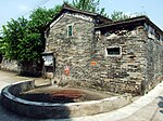
Kam Tin, or Kam Tin Heung, is an area in the New Territories, Hong Kong. It lies on a flat alluvial plain north of Tai Mo Shan mountain and east of Yuen Long town. It was formerly known as Sham Tin (岑田). Administratively, it is part of Yuen Long District. Many of Kam Tin's residents are from the Tang Clan, who are of the Punti culture, not Hakka as is often misattributed.
Excerpt from the Wikipedia article Kam Tin (License: CC BY-SA 3.0, Authors, Images).Kam Tin
Kam Tin Road, Yuen Long District
Geographical coordinates (GPS) Address Nearby Places Show on map
 Continue reading on Wikipedia
 Geographical coordinates (GPS)
| Latitude | Longitude |
|---|---|
| N 22.44 ° | E 114.065 ° |
Address
錦田街市 Kam Tin Market
Kam Tin Road
Yuen Long District
Hong Kong, China
Open on Google Maps