place

North Fork Clackamas River

Rivers of Clackamas County, OregonRivers of Oregon

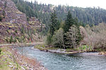
The North Fork Clackamas River is a tributary, about 11 miles (18 km) long, of the Clackamas River in the U.S. state of Oregon. Originating at nearly 4,000 feet (1,200 m) above sea level on the west side of the Cascade Range, it flows westward through Mount Hood National Forest. It joins the Clackamas at North Fork Reservoir, about 32 miles (51 km) from the larger river's confluence with the Willamette River. From source to mouth, the following tributaries enter the river: Dry Creek from the right bank, Boyer Creek from the left bank, then Whiskey, Bedford, Bee, and Fall creeks, all from the right.Elevations in the watershed range from 4,770 feet (1,450 m) in the headwaters on Tumala Mountain to 660 feet (200 m) at the river mouth. Prominent landforms include Ladee Flats, a flat-topped ridge composed of lava flows resistant to erosion. The North Fork valley is narrow and steep, and a 50-foot (15 m) waterfall 2.5 miles (4.0 km) from the mouth limits passage of migratory fish. Native rainbow and cutthroat trout are found in the upper river and its tributaries, while the lower river has winter and summer steelhead, coho salmon, spring chinook, and stocked rainbow trout.

Excerpt from the Wikipedia article North Fork Clackamas River (License: CC BY-SA 3.0, Authors).

North Fork Clackamas River
Clackamas Highway,

Geographical coordinates (GPS) Address Nearby Places
placeShow on map

Wikipedia: North Fork Clackamas RiverContinue reading on Wikipedia

Geographical coordinates (GPS)

Latitude Longitude
N 45.232222222222 ° E -122.25444444444 °
placeShow on map

Address

Clackamas Highway (State Highway 224)

Clackamas Highway

Oregon, United States
mapOpen on Google Maps

Share experience

Nearby Places

River Mill Hydroelectric Project

River Mill Hydroelectric Project, also known as River Mill Dam and Station M, is a hydroelectric dam and powerhouse in Clackamas County, Oregon, United States. It is just north of Estacada, Oregon, on the Clackamas River at river mile 23.5 (km 37.8). It received its name from being near a sawmill that was located along the river.The dam has been in continuous production of hydroelectric power since 1911, when its construction was funded by the Portland Railway, Light and Power Company. It was one of four related projects on the Clackamas River: the Oak Grove Hydroelectric Project (developed 1923–56), the North Fork dam (1958), and the Faraday Dam (1907–10), all upstream (south) of River Mill. All but Faraday, demolished 2018, are still owned and operated by the successor company, Portland General Electric. The principal designer of the original Mill Run Dam was the Norwegian immigrant Nils F. Ambursen (1876–1958). Based in Boston, his Ambursen Hydraulic Construction Company designed over a hundred dams in the United States from 1903 through 1917. Ambursen's patented concrete-slab-and-buttress dam design was a significant advance in dam design of this era. River Mill is one of only three Ambursen-type dams built west of the Mississippi, and evidently the only one to survive.The project is listed on the National Register of Historic Places, and in the Oregon Historic Sites Database of the Oregon State Historic Preservation Office.