place

Brush Hill Historic District

Federal architecture in MassachusettsHistoric districts in Norfolk County, MassachusettsHistoric districts on the National Register of Historic Places in MassachusettsMilton, MassachusettsNRHP infobox with nocat
National Register of Historic Places in Milton, MassachusettsNorfolk County, Massachusetts Registered Historic Place stubsUse mdy dates from August 2023
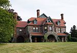
Brush Hill HD MA 01
Brush Hill HD MA 01

The Brush Hill Historic District is a residential historic district along Brush Hill Road in Milton, Massachusetts. It extends on the north side of the road from Dana Avenue to Brush Hill Lane, and on the south side from Bradlee Road to Robbins Street. Shortly before settlers migrated to Brush Hill in the 1650s, a significant forest fire struck the area causing trees to die and leaves to fall. When the settlers arrived, the hill was covered in brush, hence the name. The district includes a representative cross-section of residential development from c. 1670 to the late 1940s, and includes Milton's oldest house, the Robert Tucker House, at 678 Brush Hill Road. Brush Hill is one of the three main hills of Milton; Milton Hill, Brush Hill, and the Blue Hills.The district was listed on the National Register of Historic Places in 1998.

Excerpt from the Wikipedia article Brush Hill Historic District (License: CC BY-SA 3.0, Authors, Images).

Brush Hill Historic District
Brush Hill Road,

Geographical coordinates (GPS) Address Nearby Places
placeShow on map

Wikipedia: Brush Hill Historic DistrictContinue reading on Wikipedia

Geographical coordinates (GPS)

Latitude Longitude
N 42.245833333333 ° E -71.109722222222 °
placeShow on map

Address

Brush Hill Road 704
01286
Massachusetts, United States
mapOpen on Google Maps

Brush Hill HD MA 01
Brush Hill HD MA 01
Share experience

Nearby Places

Paul's Bridge
Paul's Bridge

Paul's Bridge is a stone bridge carrying the Neponset Valley Parkway over the Neponset River between Milton and southern Boston, Massachusetts. It was built in 1849 by Thomas Hollis, Jr., of Milton, but was later reconstructed using the original materials. It replaced the earlier Hubbard's Bridge (built prior to 1759), and a subsequent Paul's Bridge (so named at its 1807 reconstruction). Its current span is approximately 88 feet (27 m). The name "Paul" can be attributed to Samuel Paul, the owner of the adjacent land on the Readville (now Boston) side, which was part of Dedham at the time of the bridge's construction.The 1849 bridge was 81 feet (25 m) long and 22 feet (6.7 m) wide, and was constructed of unmortared Quincy granite. Each round arch measures 20 feet (6.1 m) at the springline. The area between the arches is uncoursed rubblestone, and the arches are formed out of cut granite voussoirs. The bridge underwent a major rebuilding between 1932 and 1935 under the leadership of Arthur A. Shurcliff, FASLA and founder of the AIP, who made it a priority to widen the bridge. Most of the original stone was reused and solid stone parapets replaced the wooden siderails. Instead of a rubblestone finish between the arches on the extended side, it is finished in coursed stone.Paul's Bridge was added to the National Register of Historic Places in 1972, and contributes to a historic district encompassing the Neponset River Parkway. It is located within the Neponset River Reservation, and is maintained by the Massachusetts Department of Conservation and Recreation.

Hyde Park, Boston
Hyde Park, Boston

Hyde Park is the southernmost neighborhood of Boston, Massachusetts, United States. Situated 7.9 miles south of downtown Boston, it is home to a diverse range of people, housing types and social groups. It is an urban location with suburban characteristics. Hyde Park is covered by Boston Police Department District E-18 located in Cleary Square, and the Boston Fire Department station on Fairmount Avenue is the quarters of Ladder Company 28 & Engine Company 48. Boston EMS Ambulance Station 18 is located on Dana Avenue. Hyde Park also has a branch of the Boston Public Library. The George Wright Golf Course, named for Baseball Hall of Fame and Boston Red Stockings shortstop George Wright, is in Hyde Park and Roslindale. It is a Donald Ross–designed course and is considered one of his finest designs. Hyde Park has taken the motto "A Small Town in the City" because of its suburban feel. It was the only town annexed by majority vote of the residents into the City of Boston. The area was established in the 1660s and grew into a hub of paper and cotton manufacturing in the eighteenth century. The extension of rail lines from Boston in the 1850s spurred the area's residential development. The Readville section of Hyde Park contained a large manufacturing base housing the massive operations of the B. F. Sturtevant Company and the New York, New Haven & Hartford Railroad Locomotive and Car Shops. Hyde Park and some of its residents have been important part of societal change in the United States. It was once home to the first all African-American army unit, the 54th Massachusetts Infantry Regiment. The regiment was made famous in the movie Glory. Hyde Park was home to the prominent abolitionists the Grimké sisters, Sarah and Angelina, as well as Theodore Dwight Weld, for whom Weld Hall in Hyde Park is named.