place

Suffolk Resolves House

Historical sites in the founding of the United StatesHouses completed in 1763Houses on the National Register of Historic Places in Norfolk County, MassachusettsMilton, MassachusettsNational Register of Historic Places in Milton, Massachusetts
Norfolk County, Massachusetts Registered Historic Place stubs
Suffolk Resolves House Milton MA 04

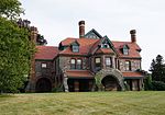
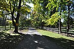
The Suffolk Resolves House is the building where the Suffolk Resolves were signed on September 4, 1774. The Resolves were an important predecessor document to the 1774 Continental Association and the 1776 Declaration of Independence. At that time, it was owned by Daniel Vose, who at his marriage had combined two existing buildings to make one house. The two parts are shown in the two gallery photographs. The oldest framing beams have been dated using dendrochronology which indicates that the trees used in the oldest portion of the house were felled in 1763.To prevent its demolition in 1950, Dr. James Bourne Ayer and Hannah Ayer moved it from its original location on Adams Street (where Citizens Bank now is) to its present location. They had it restored by William Morris Hunt and later gave it to the Milton Historical Society, for which it serves as headquarters.It was added to the National Register of Historic Places on July 23, 1973.

Excerpt from the Wikipedia article Suffolk Resolves House (License: CC BY-SA 3.0, Authors, Images).

Suffolk Resolves House
Canton Avenue,

Geographical coordinates (GPS) Address Nearby Places
placeShow on map

Wikipedia: Suffolk Resolves HouseContinue reading on Wikipedia

Geographical coordinates (GPS)

Latitude Longitude
N 42.234166666667 ° E -71.108611111111 °
placeShow on map

Address

Canton Avenue 1370
01286
Massachusetts, United States
mapOpen on Google Maps

Suffolk Resolves House Milton MA 04
Share experience

Nearby Places

Paul's Bridge
Paul's Bridge

Paul's Bridge is a stone bridge carrying the Neponset Valley Parkway over the Neponset River between Milton and southern Boston, Massachusetts. It was built in 1849 by Thomas Hollis, Jr., of Milton, but was later reconstructed using the original materials. It replaced the earlier Hubbard's Bridge (built prior to 1759), and a subsequent Paul's Bridge (so named at its 1807 reconstruction). Its current span is approximately 88 feet (27 m). The name "Paul" can be attributed to Samuel Paul, the owner of the adjacent land on the Readville (now Boston) side, which was part of Dedham at the time of the bridge's construction.The 1849 bridge was 81 feet (25 m) long and 22 feet (6.7 m) wide, and was constructed of unmortared Quincy granite. Each round arch measures 20 feet (6.1 m) at the springline. The area between the arches is uncoursed rubblestone, and the arches are formed out of cut granite voussoirs. The bridge underwent a major rebuilding between 1932 and 1935 under the leadership of Arthur A. Shurcliff, FASLA and founder of the AIP, who made it a priority to widen the bridge. Most of the original stone was reused and solid stone parapets replaced the wooden siderails. Instead of a rubblestone finish between the arches on the extended side, it is finished in coursed stone.Paul's Bridge was added to the National Register of Historic Places in 1972, and contributes to a historic district encompassing the Neponset River Parkway. It is located within the Neponset River Reservation, and is maintained by the Massachusetts Department of Conservation and Recreation.