place

Battle of Mount Gaurus

340s BC conflicts343 BC4th century BC in the Roman RepublicBattles involving the Roman RepublicBattles of the Samnite Wars
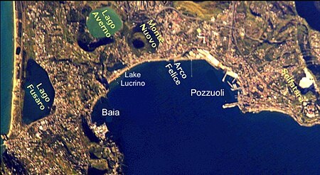
Pozzuoli NASA ISS004 E 5376 added names

The Battle of Mount Gaurus, 343 BC, was the first battle of the First Samnite War and also the first battle fought between the Roman Republic and the Samnites. The battle is described by the Roman historian Livy (59 BC – AD 17) as part of Book Seven of his history of Rome, Ab Urbe Condita Libri, where he narrates how the Roman consul Marcus Valerius Corvus won a hard-fought battle against the Samnites at Mount Gaurus, near Cumae, in Campania. Modern historians however believe that most, if not all, of the detail in Livy's description has been invented by him or his sources.

Excerpt from the Wikipedia article Battle of Mount Gaurus (License: CC BY-SA 3.0, Authors, Images).

Battle of Mount Gaurus
Via delle Colmate,

Geographical coordinates (GPS) Address Nearby Places
placeShow on map

Wikipedia: Battle of Mount GaurusContinue reading on Wikipedia

Geographical coordinates (GPS)

Latitude Longitude
N 40.848611111111 ° E 14.053611111111 °
placeShow on map

Address

Parco archeologico di Cuma

Via delle Colmate
80072
Campania, Italy
mapOpen on Google Maps

Pozzuoli NASA ISS004 E 5376 added names
Share experience

Nearby Places

Grotta di Cocceio
Grotta di Cocceio

The Grotta di Cocceio (Cocceius' Tunnel) is an ancient Roman tunnel nearly a kilometre in length connecting Lake Avernus with Cumae and dating from 38-36 BC. It was burrowed through the tuff stone of Monte Grillo by the architect Lucius Cocceius Auctus at the command of Agrippa who was in the process of converting the Lake into a military port, the Portus Julius.The tunnel was wide enough to allow the passage of two wagons. The Avernus side of the passage was decorated with a colonnade and had many statues in niches hewn into the tuff walls of the entrance. Light and air were provided by six vertical shafts dug into the hill (the longest of which was over thirty metres high) The Aqua Augusta aqueduct supplying the port was dug in a tunnel parallel to and on the northern side the road and was also equipped with niches and vertical shafts. The Crypta Romana tunnel was also built nearby from Cumae to its port in the same period, as well as other tunnels in the vicinity (e.g. the Crypta Neapolitana). With the end of the civil war between Octavian and Mark Antony in 31 BC and the displacement of the fleet from Portus Julius to the port of Misenum in 12 BC, the tunnels lost their strategic interest, but continued to be useful for practical and commercial reasons. The tunnel is also known as the Grotta della Pace, in reference to a Spanish captain, Pietro de Pace, who made use of the tunnel in 1508–1509 to plunder the ruins of Cumae, which, at the time, still bore many rich items. The Grotta was heavily damaged during World War II and is no longer open to the public. It has undergone extensive restoration works in recent years (up to 2017) and should be reopened in the near future. However, colonies of five species of legally-protected bats were discovered during the restoration, making an environmental assessment necessary before the reopening can go through.

Lucrinus Lacus
Lucrinus Lacus

Lucrinus Lacus or Lucrine Lake (Italian: Lago di Lucrino; Neapolitan: Laco 'e Lucrine) is a lake in Campania, southern Italy. It is less than one kilometre to the south of Lake Avernus and is separated from the Gulf of Pozzuoli by a narrow strip of land. Also known as the maricello ("little sea"), the size of present-day Lago Lucrino was significantly reduced by the rise of the volcanic cone of Monte Nuovo in 1538. The lake's modern dimensions are 1.5 kilometres (0.93 mi) long and about 5 metres (16 ft) deep.The recorded history of Lucrinus Lacus dates back to Sergius Orata, who is credited with creating the first oyster beds there. The lake was also a resort destination for residents of Baiae (cf. Martial i. 62). Its banks were covered with villas, of which the best known was Cicero's villa Cumanum on the east bank, which was the seat of his Academia. The remnants of this villa, and the nearby village of Tripergole, disappeared beneath ejecta from the eruption of Monte Nuovo in 1538. According to a history by Tacitus, Agrippina the Younger was murdered by the emperor Nero's assassins in her villa on the shores of Lucrinus Lacus in AD 59 after escaping an unsuccessful murder attempt while sailing on another craft nearby.The Via Herculanea and a railway traverse the strip of land between the lake and the Gulf of Pozzuoli. The ancient Via Herculanea road ran on a strip of land parallel and further to seaward from the present one and now submerged, which Strabo credited to Heracles with constructing. This strip was reinforced with a sea wall and then opened by Marcus Vipsanius Agrippa to make a harbour of Lucrinus Lacus. He then joined Lucrinis Lacus to Lago d'Averno by a canal, as recorded in Virgil's Georgics, providing a sheltered harbour known as Portus Julius for the Roman western fleet, invisible from the sea.Today Lucrino is a frazione of the comune of Pozzuoli.