Stary Kostrzynek
Gryfino County geography stubsVillages in Gryfino County

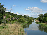
Stary Kostrzynek [ˈstarɨ kɔsˈtʂɨnɛk] (German: Altcüstrinchen) is a village in the administrative district of Gmina Cedynia, within Gryfino County, West Pomeranian Voivodeship, in north-western Poland, close to the German border. It lies approximately 8 kilometres (5 mi) south of Cedynia, 53 km (33 mi) south-west of Gryfino, and 73 km (45 mi) south-west of the regional capital Szczecin. Stary Kostrzynek is the westernmost point in Poland. Before 1945 the area was part of Brandenburg (Frankfurt Region) within Prussia, Germany. For more on the history of the region, see New March.
Excerpt from the Wikipedia article Stary Kostrzynek (License: CC BY-SA 3.0, Authors, Images).Stary Kostrzynek
Oderaue
Geographical coordinates (GPS) Address Nearby Places Show on map
Geographical coordinates (GPS)
| Latitude | Longitude |
|---|---|
| N 52.816666666667 ° | E 14.166666666667 ° |
Address
Am Polderdamm
16259 Oderaue
Brandenburg, Germany
Open on Google Maps


