Osinów Dolny
Germany–Poland border crossingsGryfino County geography stubsVillages in Gryfino County

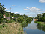
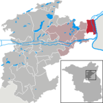
Osinów Dolny [ɔˈɕinuf ˈdɔlnɨ] (German: Niederwutzen) is Poland's westernmost settlement, in the administrative district of Gmina Cedynia, within Gryfino County, West Pomeranian Voivodeship, in north-western Poland, on the border with Germany. It lies approximately 6 kilometres (4 mi) south-west of Cedynia, 50 km (31 mi) south-west of Gryfino, and 70 km (43 mi) south-west of the regional capital Szczecin. The village has a population of 180. It is the site of a border crossing with Hohenwutzen, on the road connecting the Polish town of Chojna with Bad Freienwalde in Germany.
Excerpt from the Wikipedia article Osinów Dolny (License: CC BY-SA 3.0, Authors, Images).Osinów Dolny
124, gmina Cedynia
Geographical coordinates (GPS) Address Nearby Places Show on map
Geographical coordinates (GPS)
| Latitude | Longitude |
|---|---|
| N 52.851388888889 ° | E 14.145555555556 ° |
Address
124
74-520 gmina Cedynia
West Pomeranian Voivodeship, Poland
Open on Google Maps


