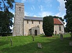
Flixton, The Saints

Flixton is a village and civil parish located in the north of the English county of Suffolk. It is around 2 miles (3.2 km) south-west of Bungay in the East Suffolk district and is one of the villages around Bungay which make up the area known as The Saints. The A143 road runs just to the north of the parish border linking Bungay with Harleston and Diss. The north-western boundary of the parish is marked by the River Waveney on the Norfolk border. As well as Bungay, the parish borders the Suffolk parishes of St Cross South Elmham, St Margaret South Elmham, Homersfield, St Peter South Elmham and Ilketshall St Margaret and the Norfolk parishes of Earsham and Denton. The parish council is joined with Flixton and St Cross and St Margaret South Elmham.At the 2011 United Kingdom census the parish had a population of 176. It was the site of a medieval Augustine priory and a World War II airfield and is the modern site of two food processing factories and an aviation museum.
Excerpt from the Wikipedia article Flixton, The Saints (License: CC BY-SA 3.0, Authors, Images).Flixton, The Saints
Church Road, East Suffolk
Geographical coordinates (GPS) Address Nearby Places Show on map
Geographical coordinates (GPS)
| Latitude | Longitude |
|---|---|
| N 52.431 ° | E 1.398 ° |
Address
Church Road
Church Road
NR35 1NU East Suffolk
England, United Kingdom
Open on Google Maps


