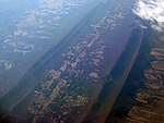
Fort Valley is a mountain valley located primarily in Shenandoah County, Virginia. It is often called "valley within a valley" as it lies between the two arms of the northern part of the Blue Ridge mountain range in the Shenandoah Valley in the Ridge-and-Valley Appalachians geological zone.
The eastern ridgeline of Fort Valley is named Massanutten Mountain and is basically continuous for the eastern length of Fort Valley, with a short stretch called Waterfall Mountain in the extreme south of the valley. The western ridgeline of the valley, also part of the greater Massanutten range, is composed primarily of three named mountains, from north to south: Three Top Mountain, Powell Mountain and Short Mountain. Additionally, behind Three Top and Powell mountains another ridgeline in the chain is called Green Mountain which is actually higher in elevation than the 3 westernmost named mountains and between which is a smaller highland valley, called Little Fort Valley. The far southern end of Fort Valley also contains a small highland sub-valley called Crisman Hollow, between Catback and Kerns mountains. Duncan's Knob at 2,800 feet, on Catback Mountain, and Strickler's Knob at over 2,700 feet on Masanutten Mountain are the two highest points in the Fort Valley ridgeline. In addition, there are several other named smaller mountains, knobs or notches within the ridges of Fort Valley, and several minor gaps or lower points between the mountains accessible only by hiking trails.
Fort Valley is almost entirely enclosed. At its southern end it is enclosed with an access point named Moreland Gap, and to the north it is constricted and nearly closed but for where Passage Creek flows through a narrow gap providing passage towards Front Royal. Passage Creek also is a prominent element of Fort Valley, running the entire length of the valley at its center, starting in Crisman Hollow in the mountain in the southernmost valley and flowing north, fed by other streams and runs, until it exits Fort Valley just past Elizabeth Furnace. The valley opens out toward the center, becoming about three miles (4.8 km) wide at its widest. The extreme southern end of the valley, the highlands of Crisman Hollow, is in Page County. The remainder of Fort Valley is in Shenandoah County, with the border of Shenandoah and Page counties being along the eastern ridgeline of Masanutten Mountain. In all, Fort Valley is 23 miles (37 km) long.
Fort Valley is entirely rural, consisting mostly of private farmland, surrounded by the George Washington National Forest (GWNF), which covers the slopes and ridges on both the east and west mountains, offering many outdoor recreation opportunities. The population of Fort Valley is 1,259 with a land area of approximately 70 square miles. The Elizabeth Furnace and Camp Roosevelt Recreation Area of the GWNF are located within Fort Valley.


