Bachtel
Appenzell AlpsCanton of Zürich geography stubsMountains of the AlpsMountains of the canton of Zürich

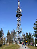
Bachtel is a mountain of the Zurich Oberland, located between Hinwil and Wald in the canton of Zurich. It lies approximately halfway between the Schnebelhorn (the highest point of the canton) and Lake Zurich. On the summit is the Bachtel Tower, a 60 metres (200 ft) tall radio tower. The Bachtel range (also Allmann or Allmen, Bachtel-Allmen-Kette) separates the Töss and Glatt basins. Extending to the north of Bachtel proper, towards Bauma, it includes Auenberg (1050 m), Allmen (1079 m) and Stüssel (1051 m).
Excerpt from the Wikipedia article Bachtel (License: CC BY-SA 3.0, Authors, Images).Bachtel
Bachtel-Trail,
Geographical coordinates (GPS) Address Nearby Places Show on map
Geographical coordinates (GPS)
| Latitude | Longitude |
|---|---|
| N 47.294722222222 ° | E 8.8863888888889 ° |
Address
Bachtel-Trail
8342
Zurich, Switzerland
Open on Google Maps


