place

Bristol, Maryland

Anne Arundel County, Maryland geography stubsUnincorporated communities in Anne Arundel County, MarylandUnincorporated communities in MarylandUse mdy dates from July 2023

Bristol is an unincorporated community in Anne Arundel County, Maryland, United States. Jug Bay Wetlands Sanctuary (a stop on the Patuxent Water Trail) and the colonial town of Pig Point (alternately referred to as Bristol Landing and Leon at times) are on the Patuxent River waterfront portion of Bristol. Pig Point saw War of 1812 action and was the county's largest steamboat port on the Patuxent in the mid-19th century. Pig Point is a very significant Native American Early Archaic Period archaeological site.The Chesapeake Beach Railway was completed in 1899 through the southern part of Bristol or "Pindell"; ruins of the Pindell Station and its general store remain. The James Owens Farm, listed on the National Register of Historic Places, and the southern terminus of the Stephanie Roper Highway portion of Maryland Route 4 are also located in Bristol. In the mid-twentieth century, the segregated Bristol Elementary School was located in the northern part of town, three-quarter mile southeast of Waysons Corner and a half mile south of the crossroad village of Drury. The school in 1953 published a history of Bristol (largely reprinting a 1927 Bristol town history from the Annapolis Capital newspaper). The following year it was enlarged and renovated, growing to 200 students (and four teachers and a heating and rodent problem) by 1969 after the county was ordered to desegregate schools in 1966.

Excerpt from the Wikipedia article Bristol, Maryland (License: CC BY-SA 3.0, Authors).

Bristol, Maryland
Wrighton Road,

Geographical coordinates (GPS) Address Nearby Places
placeShow on map

Wikipedia: Bristol, MarylandContinue reading on Wikipedia

Geographical coordinates (GPS)

Latitude Longitude
N 38.791666666667 ° E -76.672222222222 °
placeShow on map

Address

Wrighton Road 1021
20711
Maryland, United States
mapOpen on Google Maps

Share experience

Nearby Places

Mount Pleasant (Upper Marlboro, Maryland)

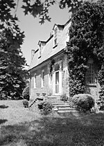
Mount Pleasant is 2+1⁄2-story brick structure with a gambrel roof and is about two-thirds its original length. It is located near Upper Marlboro in Prince George's County, Maryland. Mount Pleasant was patented in 1697 to Richard Marsham, whose wife Anne was the daughter of Leonard Calvert, Governor of Maryland. Their grandson, Marsham Waring, inherited the home from his grandfather in 1713. His son, Richard Marsham Waring had a son, Richard Marsham Jr., born in 1733, who then inherited Mount Pleasant and Patented and Certified the tract of land dubbed "Mount Pleasant Enlarged" in 1760. On August 21, 1764, Richard Marsham Jr. sold the 451+3⁄4 acre tract of land to his brother John for £474.6s.9d. John later built the standing house in the years between 1764 and 1785 (conflicting dates). John died in 1813 and was buried at Mount Pleasant.Mount Pleasant is an example of an almost distinctively Maryland style of house—the English gambrel roof dwelling in brick, with the steep gambrel which has dormers almost flush with the second pitch of the roof. This house is significant primarily for its architecture and as a representative example of a more modest type of mid-Georgian dwelling than others in Maryland such as Montpelier, and probably a closer reflection of the architectural ancestry than the Palladian country house. As a more modest dwelling Mount Pleasant is an unusual survivor.Thomas Fielder Bowie is interred in the Waring family burial ground on this site.