place

Tattenhall Road railway station
Beeching closures in EnglandDisused railway stations in CheshireFormer London and North Western Railway stationsNorth West England railway station stubsPages with no open date in Infobox station
Railway stations in Great Britain closed in 1966Railway stations in Great Britain opened in 1840Use British English from October 2017
Tattenhall Road railway station

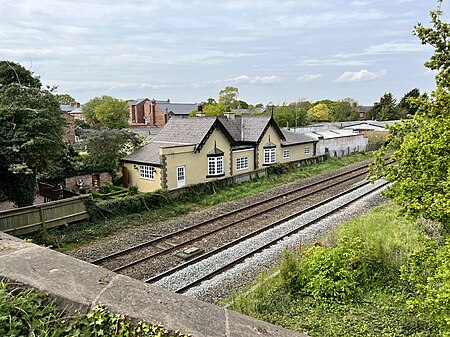
Tattenhall Road railway station was a railway station situated a mile to the north of the village of Tattenhall, Cheshire on the Chester and Crewe Railway that was built in 1840 linking Chester to the north-west with Crewe to the south-east. The track now forms part of the North Wales Coast Line. The station was named Tattenhall Road in 1872 to distinguish it from another Tattenhall railway station, a little to the west of the village, on the Whitchurch and Tattenhall Railway branch line to Whitchurch. The station took back the name Tattenhall when the branch line closed in 1957. It was then itself closed in 1966. The station building still exists, now as a private house.

Excerpt from the Wikipedia article Tattenhall Road railway station (License: CC BY-SA 3.0, Authors, Images).

Tattenhall Road railway station
Tattenhall Road, Chester Tattenhall and District

Geographical coordinates (GPS) Address External links Nearby Places
placeShow on map

Wikipedia: Tattenhall Road railway stationContinue reading on Wikipedia

Geographical coordinates (GPS)

Latitude Longitude
N 53.1381 ° E -2.7574 °
placeShow on map

Address

Tattenhall Road

Tattenhall Road
CH3 9AZ Chester, Tattenhall and District
England, United Kingdom
mapOpen on Google Maps

linkWikiData (Q7688389)
linkOpenStreetMap (17307229)

Tattenhall Road railway station
Share experience

Nearby Places

Huxley Hoard
Huxley Hoard

The Huxley Hoard is a hoard of Viking jewellery from around 900-910 found buried near Huxley, Cheshire, England. It consists of 21 silver bracelets, one silver ingot, and 39 lead fragments, weighing around 1.5 kilograms (3.3 lb) in total. The bracelets might have been produced by Norse settlers in Dublin and possibly buried for safekeeping by Viking refugees settling in Cheshire and the Wirral in the early 900's. It was discovered by Steve Reynoldson in November 2004 after he found fragments of lead 30 centimetres (12 in) underground using a metal detector.The bracelets were folded flat, sixteen decorated by punched patterns, six with crosses stamped in their centre, and another six with centre cross and one at each end. Two have lattice patterns, one an hourglass stamp around the edge, one chevrons with central and end crosses, and one (found as a twisted bar) a zig-zag pattern; the remaining four are plain. The lead fragments suggest the hoard could have been buried either in a lead sheet or a lead-lined wood box.One of a cluster of hoards found in the Chester area, it was held by the British Museum until early 2007 before making a July 2007 debut at the Merseyside Maritime Museum. A Heritage Lottery Fund grant of £45,000 enabled its purchase by joint owners Grosvenor Museum, Cheshire Museums Service and National Museums Liverpool, who have it on display at the Museum of Liverpool. It was the subject of a book published by the National Museums Liverpool in 2010.