Virginia Village, Denver

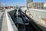
Virginia Village is a neighborhood of Denver, Colorado, roughly five miles southeast of downtown. The neighborhood consists of a mixture of town homes, single-family homes, shopping plazas, and mid to high-rise apartment and office buildings. It is served by the Colorado Station on the E, F, and H RTD light rail lines. The neighborhood is bounded on the west by Colorado Boulevard; on the southwest by Interstate 25; on the south by Evans Avenue; on the east by Quebec Street; on the northeast by Cherry Creek; and on the north by Mississippi Avenue. Holly Street divides the Virginia Village neighborhood into two areas, each represented by a neighborhood association. The area west of Holly Street comprises the Virginia Village Ellis Community Association, while the area to the east of Holly comprises the Cook Park Neighborhood Association.
Excerpt from the Wikipedia article Virginia Village, Denver (License: CC BY-SA 3.0, Authors, Images).Virginia Village, Denver
East Mexico Avenue, Denver
Geographical coordinates (GPS) Address Nearby Places Show on map
Geographical coordinates (GPS)
| Latitude | Longitude |
|---|---|
| N 39.68539 ° | E -104.92416 ° |
Address
East Mexico Avenue 5418
80222 Denver
Colorado, United States
Open on Google Maps


