place

Blue Lake Regional Park
College cross country courses in the United StatesCross country running courses in OregonGeographic coordinate listsLakes of Multnomah County, OregonLakes of Oregon
Landforms of Multnomah County, OregonLists of coordinatesParks in Multnomah County, OregonParks in OregonPortland State VikingsWetlands of Oregon
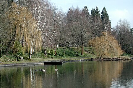
Blue Lake shoreline
Blue Lake shoreline

Blue Lake Regional Park is a public park in Fairview, in the U.S. state of Oregon. The 101-acre (41 ha) park, near the south shore of the Columbia River in Multnomah County, includes many covered and uncovered picnic areas, playing fields for sports such as softball, a cross country course (home course for Portland State Vikings cross country) and infrastructure related to lake recreation including swimming, boating, and fishing. Encompassing wooded areas, three ponds, and a wetland in addition to the lake, the park is frequented by migrating birds and other wildlife. Paved paths run through the park, which is near the 40-Mile Loop hiking and biking trail. Park vegetation includes cottonwoods, willows, and other trees and shrubs as well as wetland plants such as cattails. The 61-acre (25 ha) lake, which lies in a small artificial drainage basin, has no natural inlet or outlet. Water normally enters the lake only from rain, surface runoff, and groundwater seepage. Excessive aquatic plant life and algae have sometimes restricted the use of the lake, and its maintenance includes plant control and addition of fresh water from municipal wells.

Excerpt from the Wikipedia article Blue Lake Regional Park (License: CC BY-SA 3.0, Authors, Images).

Blue Lake Regional Park
Northeast Blue Lake Road,

Geographical coordinates (GPS) Address Nearby Places
placeShow on map

Wikipedia: Blue Lake Regional ParkContinue reading on Wikipedia

Geographical coordinates (GPS)

Latitude Longitude
N 45.5565082 ° E -122.4481473 °
placeShow on map

Address

Northeast Blue Lake Road
97024
Oregon, United States
mapOpen on Google Maps

Blue Lake shoreline
Blue Lake shoreline
Share experience

Nearby Places

Fairview Creek
Fairview Creek

Fairview Creek is a 5-mile (8.0 km) tributary of the Columbia Slough in the U.S. state of Oregon. The creek forms in a wetland near Grant Butte in Gresham and flows north for 5 miles (8.0 km) to Fairview Lake in Fairview. Grant Butte, rising to 602 feet (183 m) above sea level, is one of eight dormant volcanic formations near Gresham. Fairview Creek begins northeast of the butte at an elevation of 278 feet (85 m) and falls to an elevation of 10 feet (3.0 m) at the lake.The creek is a former tributary of the Columbia River, which it reached by flowing north through wetlands in the Columbia's floodplain. In the early 20th century, an artificial channel diverted the water from these wetlands to the Columbia Slough, a tributary of the Willamette River. In 1960, water managers built a dam to create Fairview Lake for water storage and recreation. The lake covers about 100 acres (40 ha) and is 5 feet (1.5 m) to 6 feet (1.8 m) deep. Fairview Creek has two named tributaries, No Name Creek, and Clear Creek. A smaller stream, Osburn Creek, also flows into Fairview Lake, which empties through a weir and culvert system on the west side of the lake into the upper slough.In 2002, the City of Gresham adopted a plan for a 5.2-mile (8.4 km) hiking and biking trail to run partly along the creek. The trail was designed to provide a north-south connection between the Springwater Corridor Trail along Johnson Creek to the south and the 40-Mile Loop trail along the Columbia River. As of 2008, a 1.24-mile (2.00 km) segment of the trail between Northeast Halsey Street and Northeast Burnside Road was open to the public. Unfinished segments between Northeast Halsey and the Springwater Corridor are expected to be ready by autumn 2009. If so, at that point 3.49 miles (5.62 km) of the trail will be open to the public.

Jacob Zimmerman House

Jacob Zimmerman House was the home of Jacob and Lena Zimmerman, German American settlers who came west over the Oregon Trail in 1851 to what became Multnomah County in the U.S. state of Oregon. Built in 1874, the house was part of a 600-acre (240 ha) dairy farm. Members of the Zimmerman family lived on the farm from 1870 through 1992. The house and 1.58 acres (6,400 m2) were added to the National Register of Historic Places in 1986. In 1994, the city of Gresham began land acquisition and planning for a 5.98-acre (2.42 ha) public park, Zimmerman Heritage Farm, with the house as its centerpiece.The city, which owns the land, and the Fairview-Rockwood-Wilkes Historical Society (FRWHS), which owns the house, manage the Zimmerman Heritage Farm through a partnership. In 1992, the FRWHS acquired the house from Isobel Faith Zimmerman, the youngest granddaughter of the original owners. By late 2006, the society had spent an estimated $170,000 on rebuilding the foundation, upgrading the security system, fixing the porch, repairing the chimneys, replacing the roof and gutters, painting the exterior, and other work. The house is open for public tours on the third Saturday of each month from 10 a.m. to 3 p.m.The Zimmermans were among the five founding families of Fairview. They arrived in the Willamette Valley in 1851 and settled on Hayden Island in the Columbia River. After floods destroyed their first crops, they re-located to a 320-acre (130 ha) donation land claim about 10 miles (16 km) east of Portland. In late 1869, Jacob Zimmerman bought another donation land claim and moved into a log cabin on this site until building the original house in 1874. The Zimmermans' son, George, enlarged the farm to 660 acres (270 ha) on which he ran a successful dairy business that continued under several relatives and lessees into the 20th century.