place

Aqueduct of Vanvitelli
Aqueducts in ItalyBuildings and structures in CampaniaBuildings and structures in CasertaLuigi Vanvitelli buildingsNeoclassical architecture in Campania
World Heritage Sites in Italy
Vanvitelli aqueduct
Vanvitelli aqueduct

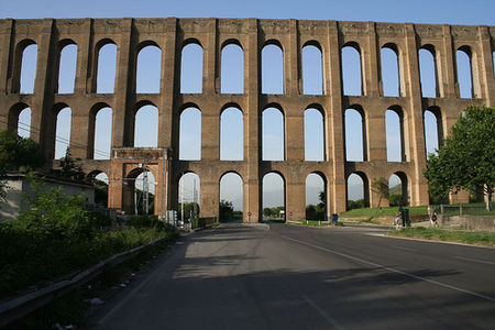
The Aqueduct of Vanvitelli or Caroline Aqueduct is a 38 km aqueduct that supplied water to the Reggia di Caserta and the San Leucio complex from the foot of the Taburno massif and springs of the Fizzo Contrada, in the territory of Bucciano. Mostly underground, the aqueduct is noted for its well-preserved, three-tier, 529-metre-long (1,736 ft) tufa-arched section bridging the Valle di Maddaloni between Monte Longano (to the east) and Monte Garzano (to the west). This section was modelled after Roman arched aqueducts, is 55.8 metres (183 ft) high at its highest point, crosses what is now highway SP335 — and was designated a World Heritage Site in 1997. Commissioned by Charles of Bourbon, the aqueduct was designed by and named after Luigi Vanvitelli. Construction began in March 1753 and it opened on 7 May 1762. It is located in SS265, 81020 Valle di Maddaloni CE, Italy.

Excerpt from the Wikipedia article Aqueduct of Vanvitelli (License: CC BY-SA 3.0, Authors, Images).

Aqueduct of Vanvitelli
Strada Statale 265 Variante dei Ponti della Valle,

Geographical coordinates (GPS) Address Nearby Places
placeShow on map

Wikipedia: Aqueduct of VanvitelliContinue reading on Wikipedia

Geographical coordinates (GPS)

Latitude Longitude
N 41.059166666667 ° E 14.401666666667 °
placeShow on map

Address

Strada Statale 265 Variante dei Ponti della Valle

Strada Statale 265 Variante dei Ponti della Valle
81024
Campania, Italy
mapOpen on Google Maps

Vanvitelli aqueduct
Vanvitelli aqueduct
Share experience

Nearby Places

Calatia
Calatia

Cālātia was an ancient town of Campania, southern Italy, c. 10 km southeast of Capua, on the Via Appia, near the point where the Via Popillia branches off from it. It is represented by a locality known as Villa Galazia and by the church of San Giacomo alle Galazze (or San Giacomo delle Galazze or San Giacomo Le Galazze), within the modern town of Maddaloni, very near the boundary with the neighboring town of San Nicola la Strada, and right on the Via Appia. The Via Appia here, as at Capua, abandons its former SE direction for a length of 2,000 Oscan feet (500 m), for which it runs due east and then resumes its course SE. Ruins include remains of the walls (with sector from the Samnite age, in tuff, and others from the Sulla period) and the pre-Roman necropolis was partially excavated in 1882. The ten shafts lined with slabs of tuff which may have been the approaches to tombs or may have served as wells.The history of Calatia is similar to that of its more powerful neighbor Capua, but as it lay near the point where the Via Appia turns east and enters the mountains, it had some strategic importance. In 313 BC it was taken by the Samnites and recaptured by the dictator Fabius Maximus Rullianus; the Samnites captured it again in 311 BC, but it must have been retaken at an unknown date. In the 3rd century BC we find it issuing coins with an Oscan legend, but in 211 BC it shared the fate of Capua. In 174 BC it is mentioned that its walls were being repaired by the censors. In 59 BC a colony was established here by Caesar.