Ländchen
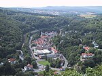
The Ländchen was a region east of Wiesbaden, Germany that comprised ten villages: Breckenheim, Delkenheim, Diedenbergen, Igstadt, Langenhain, Massenheim, Medenbach, Nordenstadt, Wallau, and Wildsachsen, plus Domäne Mechtildshausen. Ländchen was a Hessian territory for about 300 years. It was bounded by the County of Nassau to the west and the territory of the Archbishopric of Mainz to the east. (It is distinct from the Blue Ländchen at Nastätten.) Breckenheim, Delkenheim, Igstadt, Medenbach, and Nordenstadt are now boroughs of Wiesbaden. Domäne Mechtildshausen is also part of the borough of Wiesbaden-Erbenheim. Diedenbergen, Langenhain, Wallau, and Wildsachsen are now boroughs of Hofheim am Taunus. Massenheim is a borough of Hochheim am Main. The Ländchen gives its name to a railway line, the Ländchesbahn, which traverses this territory.
Excerpt from the Wikipedia article Ländchen (License: CC BY-SA 3.0, Authors).Ländchen
Beinstraße, Wiesbaden
Geographical coordinates (GPS) Address Nearby Places Show on map
Geographical coordinates (GPS)
| Latitude | Longitude |
|---|---|
| N 50.083333333333 ° | E 8.3666666666667 ° |
Address
Beinstraße
Beinstraße
65207 Wiesbaden
Hesse, Germany
Open on Google Maps


