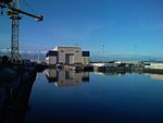
Barrow Island, Barrow-in-Furness
AC with 0 elementsBarrow-in-Furness port and shipyardDistricts of Barrow-in-FurnessFormer islands of EnglandIslands of Furness ... and 3 more
Protected areas of CumbriaUse British English from April 2017Wards of Barrow-in-Furness

Barrow Island is an area and electoral ward of Barrow-in-Furness, Cumbria, England. Originally separate from the British mainland, land reclamation in the 1860s saw the northern fringes of the island connected to Central Barrow. Barrow Island is also bound to the south and east by the town's dock system and to the west by Walney Channel. The Ward population taken at the 2011 census was 2,616.
Excerpt from the Wikipedia article Barrow Island, Barrow-in-Furness (License: CC BY-SA 3.0, Authors, Images).Barrow Island, Barrow-in-Furness
Geographical coordinates (GPS) Address Nearby Places Show on map
Geographical coordinates (GPS)
| Latitude | Longitude |
|---|---|
| N 54.103 ° | E -3.232 ° |
Address
LA14 2TL , Barrow Island
England, United Kingdom
Open on Google Maps


