place

Portas do Cerco

1573 establishments in China1573 establishments in the Portuguese Empire16th-century establishments in Macau1870 establishments in China1870 establishments in the Portuguese Empire
19th-century establishments in MacauBuildings and structures in MacauChina–Macau border crossingsGatesMacau PeninsulaPortuguese MacauPortuguese colonial architecture in China
Brána obležení, Macao

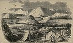
The Portas do Cerco is an area in Nossa Senhora de Fátima, Macau, China. Located on the northern tip of the Macau Peninsula, it is known by the Barrier Gate separating Macau from mainland China. The Portuguese built the gate in 1849 to replace a crumbling wall that the Chinese erected during the Ming dynasty in 1573. The Chinese built a garrisoned wall to control the flow of people and goods. It was the site of the Passaleão incident, a clash between the Qing dynasty and the Kingdom of Portugal in 1849 over the death of Macau's governor Ferreira do Amaral. Led by Colonel Mesquita, Portugal won the small battle which led to the extension of Macau's border northwards. At the limit of said expansion, the Portas do Cerco was built with the inscription "A pátria honrai, que a pátria vos contempla" (Portuguese for "Honor your fatherland, for your fatherland looks over you") on the façade on its inner arch in 1849. The Barrier Gate served as a de facto boundary, but the precise limits of Macau's border has never been formally demarcated.Macau, now a special administrative region of China, still has an official border with Zhuhai in mainland China a few meters behind the old barrier gate. The new Posto Fronteiriço das Portas do Cerco (Barrier Gate Border Post) was opened on 15 January 2004.

Excerpt from the Wikipedia article Portas do Cerco (License: CC BY-SA 3.0, Authors, Images).

Portas do Cerco
關閘廣場 Praça das Portas do Cerco,

Geographical coordinates (GPS) Address Nearby Places
placeShow on map

Wikipedia: Portas do CercoContinue reading on Wikipedia

Geographical coordinates (GPS)

Latitude Longitude
N 22.2147 ° E 113.5488 °
placeShow on map

Address

關閘廣場 Praça das Portas do Cerco

關閘廣場 Praça das Portas do Cerco
519020 , 關閘 Portas do Cerco
Macau, China
mapOpen on Google Maps

Brána obležení, Macao
Share experience

Nearby Places

Mong-Há Fort
Mong-Há Fort

Mong-Há Fort (Chinese: 望廈炮台; Portuguese: Fortaleza de Mong-Há) is a fort on Mong-Há Hill, Nossa Senhora de Fátima, Macau, China. The fort is part of a greater military reservation – the Bairro Militar de Mong-Há, which included the Quartel de Mong-Há (Mong-Há Barracks). The Bairro Militar is bound by the Rua Francisco Xavier Pereira and the Colina de Mong-Há. The main fort complex was erected 1849 by Governor Ferreira do Amaral to protect the Macau's northern sector as precaution against a possible Chinese invasion following the First Opium War between Britain and China (1839–1842). The fort's construction began in 1849 and was completed in 1864/66. The Quartel de Mong-Há was constructed in the 1920s. With the complete withdrawal of the Portuguese military establishment in the 1960s following the Sino-Portuguese rapprochement, the fort and the Bairro Militar were deactivated, with the former being turned over to the Instituto de Formação Turística de Macau in the 1980s. In June 1997, the area surrounding the fort was transformed into the Jardim Municipal de Mong-Há. With an overall area of 650 square meters, the brick-walled fort held ten artillery pieces with a firing range capable of reaching the Portas do Cerco. Along with the barracks for Portuguese troops of African origin (Landins), the fort also included a lookout post and a munitions dump. The Quartel de Mong-Há occupied an area of 2244 square meters and was built in the style of 1920s Southern European and Modernist architecture. The government of Macau demolished the Quartel de Mong-Há and the neighboring Escola Keang Peng and put in their place public housing in the name of public security in late 2008.