Hesket, Victoria
Mallee geography stubsShire of Macedon RangesTowns in Victoria (state)Use Australian English from August 2019

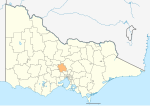
Hesket is a locality in the Macedon Ranges Shire, in Victoria, Australia on the northern side of the Mount Macedon Range. The settlement was originally known as Ferny Creek.Hesket Post Office opened on 1 November 1866 and closed in 1971.Today the locality consists of the Hesket Primary School (State School 1004) and the Hesket-Kerrie CFA fire station.
Excerpt from the Wikipedia article Hesket, Victoria (License: CC BY-SA 3.0, Authors, Images).Hesket, Victoria
Bowens Road, Shire of Macedon Ranges
Geographical coordinates (GPS) Address Nearby Places Show on map
Geographical coordinates (GPS)
| Latitude | Longitude |
|---|---|
| N -37.35 ° | E 144.61666666667 ° |
Address
Bowens Road (Falls Road)
Bowens Road
3442 Shire of Macedon Ranges (Hesket)
Victoria, Australia
Open on Google Maps


