place

Frölunda Specialist Hospital

1968 establishments in SwedenEuropean hospital stubsHospital buildings completed in 1968Hospitals established in 1968Hospitals in Gothenburg
Swedish building and structure stubs
Frölunda Specialistsjukhus

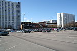
Frölunda specialist hospital (Swedish: Frölunda Specialistsjukhus) is located in Frölunda, right next to Frölunda torg, approximately nine kilometres south-west of central Gothenburg. The hospital primarily operate with elective care, with specialist in otolaryngology, neurology, gynaecology, orthopedic surgery, medicine, dermatology, ophthalmology, surgery, and radiography. The hospital was inaugurated in 1968 as a local hospital for people living in Tynnered, Frölunda, and Älvsborg. Today, 190 people work at the hospital which is owned by Västra Götaland Regional Council. The 17-storey building is 55 metres (180 ft) high. The hospital occupies the bottom five floors; the rest are residential.

Excerpt from the Wikipedia article Frölunda Specialist Hospital (License: CC BY-SA 3.0, Authors, Images).

Frölunda Specialist Hospital
Lergöksgatan, Gothenburg Västra Frölunda (Sydväst)

Geographical coordinates (GPS) Address External links Nearby Places
placeShow on map

Wikipedia: Frölunda Specialist HospitalContinue reading on Wikipedia

Geographical coordinates (GPS)

Latitude Longitude
N 57.650555555556 ° E 11.912222222222 °
placeShow on map

Address

Frölunda specialistsjukhus

Lergöksgatan
421 44 Gothenburg, Västra Frölunda (Sydväst)
Sweden
mapOpen on Google Maps

linkWikiData (Q5506755)
linkOpenStreetMap (45100043)

Frölunda Specialistsjukhus
Share experience

Nearby Places

Askim, Sweden

Askim (Swedish pronunciation: [ˈâɧːɪm]) is a district (stadsdelsnämndsområde) of the Gothenburg Municipality in Sweden, about 10 km (6 mi) south-west of the city centre. To the northwest of Askim is Västra Frölunda, to the east is Mölndal, and the sea is to the west. As a district, Askim has a local board composed of the same proportions ruling Gothenburg as a whole. The voting base in Askim is predominantly bourgeoisie, while Gothenburg as a whole has a social democratic, socialist and environmentalist majority. This has caused some local tensions due to the strong liberal movement, and a strong local movement works to once again make Askim a separate municipality (kommun). Askim was traditionally inhabited by fishermen. It is now a predominantly upper-middle class area with golf clubs, yacht clubs, and large houses. The less expensive areas are popular with families with children due to a reputation for safety and good schools. The district of Askim is divided into smaller parts, including Askim, Hovås, Billdal and Skintebo. Beneath Askim lies many historical artifacts dating back to the Stone Age. Many worked pieces of rock show evidence of these times. It is on the Askim coast, a part of Kattegatt, and has a mountainous terrain. Most of the buildings, which comprise mainly privately owned homes, are concentrated along the coast. The people living here have a much higher income compared to other average citizens of both Gothenburg and Sweden. The football team is Askims IK, whose coach is the famous ex-player Pontus Kåmark, who played in the Sweden national team in 1994.

1977 World Masters Athletics Championships

1977 World Masters Athletics Championships is the second in a series of World Masters Athletics Outdoor Championships (called World Masters Championships or World Veterans Championships at the time) that took place in Gothenburg, Sweden, from 8 to 13 August 1977.The main venue was Slottsskogsvallen. : 1 : 46  Supplemental venues included Ullevi Stadium for 5K and 10K races, the former Gothenburg-Särö railroad route for Marathon, and the park around Björngårdsvillan for Cross Country and Road Walks. This edition of masters athletics Championships had a minimum age limit of 35 years for women and 40 years for men. : 4  The age groups for women are now in 5-year (rather than 10-year as in 1975) divisions, same as for men. : 3 The governing body of this series is World Association of Veteran Athletes (WAVA, initially called World Veterans Athletic Association). : 2  WAVA was formed during meeting at the inaugural edition of this series at Toronto in 1975, then officially founded and named when its constitution was proposed during General Assembly at this edition on 9 August 1977. : 47 : 167 : 4 : 2 : 7  WAVA was renamed as World Masters Athletics (WMA) at the Brisbane Championships in 2001. : 4 : 56 This Championships was organized by the nascent WAVA in coordination with a Local Organising Committee (LOC) led by Roland Jerneryd ( SWE). Jerneryd was elected WAVA secretary at the General Assembly. : 2 : 166 : 47 In addition to a full range of track and field events, non-stadia events included 8K Cross Country and Marathon.

Göta älv
Göta älv

The Göta älv (Swedish pronunciation: [ˈjø̌ːta ˈɛlv]; "River of (the) Geats") is a river that drains lake Vänern into the Kattegat, at the city of Gothenburg, on the western coast of Sweden. It was formed at the end of the last glaciation, as an outflow channel from the Baltic Ice Lake to the Atlantic Ocean and nowadays it has the largest drainage basin in Scandinavia. The Göta älv is located in Götaland, with the river itself being a site of early Geatish settlement. Its length is 93 km (58 mi). The Bohus Fortress is located by the river at Kungälv. There the river splits into two, with the northern part being the Nordre älv and the southern part keeping the name Göta älv; the two arms of the river enclose the island of Hisingen. At Trollhättan there is a dam, canal locks and a hydropower station in the river. The locks make the river navigable, even for large cargo vessels (88 m [289 ft] long). The artificial parts are called Trollhätte Canal. The river and the canal is part of a mostly inland waterway, Göta Canal, which spans the width of Sweden to the Baltic Sea south of Stockholm. The power station supplied electric power to the heavy steel industry concentrated around Trollhättan Falls, contributing to its industrial revolution. In the summer months the spillway of the dam is opened for a few minutes daily and tourists gather to see the water rushing down the river (picture). There are concerns about whether the maximum permitted discharge of 1,000 m3/s (35,000 cu ft/s) is enough in a scenario where heavy rain floods the lake Vänern, causing considerable damage. Previously this was thought not to be possible in reality, but in 2001 the lake was flooded almost 1 m (3 ft) above maximum level (and some upstream lakes like Glafsfjorden flooded 3 m [10 ft]). In this situation, Göta älv was allowed a discharge of 1,100 m3/s (39,000 cu ft/s) for months causing a big risk of landslides. Now a water tunnel between Vänersborg and Uddevalla is considered as a rescue solution. There is a large risk of landslides along the river and historical records of 15 landslides exist. The largest occurred in the years 1150, 1648, 1950, 1957 and 1977 (Tuve landslide).