place

Lawyers Hill Historic District

Baltimore metropolitan area Registered Historic Place stubsElkridge, MarylandGeorgian architecture in MarylandGothic Revival architecture in MarylandHistoric districts in Howard County, Maryland
Historic districts on the National Register of Historic Places in MarylandHoward County, Maryland geography stubsNRHP infobox with nocatNational Register of Historic Places in Howard County, MarylandQueen Anne architecture in MarylandUse mdy dates from August 2023
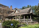
Lawyers Hill House Sept 09

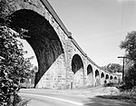
The Lawyers Hill Historic District is a national historic district located at Elkridge, Howard County, Maryland. The district encompasses a broad array of architectural styles ranging from 1738 Georgian Colonial to 1941 Georgian Revival. The collection of Victorian domestic architecture built during the 1840s to 1880s is unparalleled in the county, with no two houses the same. Some of the later cottages were designed by Philadelphia architect Brognard Okie. There are variations of the American Gothic Revival form, Italianate, Queen Anne, and Shingle-style structures. There is also a range of Colonial Revival houses, from craftsman era rustic cottages to more formal Georgian, and mass-produced Dutch Colonial models from the early 20th century.The area developed originally in the 19th century as a summer community and early commuter suburb for prominent Baltimoreans. With the opening of the Thomas Viaduct in 1836, the Patapsco Valley south of the river was easily accessible to Baltimoreans. Many of the first residents were respected lawyers and doctors active in many of the professional and cultural organizations still vital in the state today. During the 1840s, as railroad service improved, Lawyers Hill residents began commuting to Baltimore on a daily and weekly basis, establishing the community as the state's first railroad commuter suburb.It was listed on the National Register of Historic Places in 1993.

Excerpt from the Wikipedia article Lawyers Hill Historic District (License: CC BY-SA 3.0, Authors, Images).

Lawyers Hill Historic District
Hop The Snake,

Geographical coordinates (GPS) Address Website Nearby Places
placeShow on map

Wikipedia: Lawyers Hill Historic DistrictContinue reading on Wikipedia

Geographical coordinates (GPS)

Latitude Longitude
N 39.22 ° E -76.731388888889 °
placeShow on map

Address

Patapsco Valley State Park Avalon Area

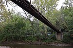
Hop The Snake
21075
Maryland, United States
mapOpen on Google Maps

Website
dnr.maryland.gov

linkVisit website

Lawyers Hill House Sept 09
Share experience

Nearby Places

Hockley Forge and Mill

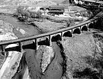
The Hockley Forge and Mill are a collection of colonial-era industrial buildings along the Patapsco River near modern Elkridge, Maryland. Located at the river's head of navigation, the site is a flat section of land along the Patapsco River valley with steep embankments on either side. At its 19th-century peak, the site held more than 30 industrial buildings. Initially, the site was the Patapsco crossing of the "Old Indian Road" surveyed by Oliver Cromwell in 1734. In 1760, the forge site was surveyed by Edward Norwood; the forge itself was founded June 14 by Charles Carroll of Carrollton as the "Baltimore Company. Other partners included Charles Carroll of Duddington, Daniel and Walter Dulany, Charles Carroll (barrister) and Benjamin Tasker, Sr. who also operated two other forges. Operated by slaves, the forge produced goods to replace ones imported from England.When the old Baltimore forge burned down in April 1772, slaves were sent to work at the Hockley Forge.In 1781, the state of Maryland seized the company once owned in part by two Dulany cousins who were loyal to the British. Dan Dulany of Baltimore owned a remaining interest in the forge, and wrote the state to reimburse him for the loss in value due to losses sustained by loyalists in the colonial war. He cited that at the time, the forge property contained 100 acres and was operated by 98 slaves valued at 40 pounds each.Forge work depended on a declining supply of coal and wood which idled the plant in 1783. In 1794, Christopher Johnston purchased the property and sold the equipment from the slitting mill to George Elliott for his upstream mill in 1807. The property was auctioned on September 16, 1819, renovated by the Carroll and Oliver families and resold in 1822. A large distillery operation was put into operation by John McKim Jr. which ceased by 1833 when the Thomas Viaduct construction began. The mill continued in operation by George T Worthington until a fire in 1856. In 1868, a major flood damaged the four-story mill. The Levering family acquired the site and sold it in 1876 to the Viaduct Manufacturing Company. A street through the site is now named Levering Avenue. From 1906-1910, a 20-by-30-foot room was rented to Marion B. Davis, who manufactured brass screw threads and socket assemblies for automobiles delivered by horse and carriage. The Viaduct Company produced telegraph equipment onsite until it was abandoned in 1914. Since 1914, most of the remaining buildings have been demolished or destroyed by fire or flood.