West Point, Hong Kong

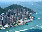
West Point (Chinese: 西點,或稱西角) was a point of land on Hong Kong Island, Hong Kong. Its location is the shore off Pok Fu Lam Road and Queen's Road West in 1845, approximately the junction of Western Street and Des Voeux Road West near Western Police Station. This was the northernmost point on the western half of Hong Kong Island. The Hong Kong Government divided Victoria City into four wan (環), or districts. While West Point falls into Sai Wan, or Western District, major government structures like the police station and court (Western Magistracy) are located near West Point. Thus the name of Sai Wan, Western District, Western and West Point were sometimes used interchangeably. St. Stephen's Anglican Church located in West Point was founded by the Church Missionary Society (Church Mission Society) (CMS) in 1865. It was led by Vicar Tsing-Shan Fok 霍靜山 (1851-1918), one of the earliest Chinese clergymen in Hong Kong, beginning in 1904.
Excerpt from the Wikipedia article West Point, Hong Kong (License: CC BY-SA 3.0, Authors, Images).West Point, Hong Kong
Queen's Road West, Hong Kong Island Sai Ying Pun (Central and Western District)
Geographical coordinates (GPS) Address Nearby Places Show on map
 Continue reading on Wikipedia
 Geographical coordinates (GPS)
| Latitude | Longitude |
|---|---|
| N 22.286986111111 ° | E 114.14045833333 ° |
Address
西區員佐級已婚宿舍 Western Police R & F Married Quarters
Queen's Road West
Hong Kong Island, Sai Ying Pun (Central and Western District)
Hong Kong, China
Open on Google Maps