place

Our Lady of the Wayside Church
1912 establishments in California20th-century Roman Catholic church buildings in the United StatesCalifornia Historical LandmarksChurches in San Mateo County, CaliforniaChurches on the National Register of Historic Places in California
History of San Mateo County, CaliforniaMission Revival architecture in CaliforniaNational Register of Historic Places in San Mateo County, CaliforniaPortola Valley, CaliforniaRoman Catholic churches completed in 1912Roman Catholic churches in California
OurLadyoftheWayside
OurLadyoftheWayside

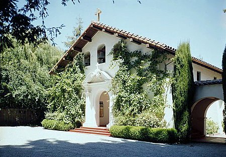
Our Lady of the Wayside Church is a modest church built in 1912 for the then-growing Catholic parish of Portola Valley by a combined effort of Jewish, Protestant and Catholic members of The Family, a San Francisco men's club that owns a nearby rural retreat. The building itself was constructed of steel-reinforced concrete with stucco finish in the Mission Revival style, with the added Georgian element of the main doorway with its scrolled pediment. Mission Revival features include the tiled gable roof with exposed rafter ends, round-arched windows and buttressed side walls.James Rupert Miller, an architect and a member of The Family, gave the assignment of designing the church to a rising young draftsman at his firm: Timothy L. Pflueger. The building was 19-year-old Pflueger's first commission. Pflueger drew on his familiarity with Mission San Francisco de Asís in his native San Francisco for inspiration.In 1977, a plaque was placed proclaiming the building as California Registered Historical Landmark number 909. The church was also added to the National Register of Historic Places in 1977.The historic church suffered extensive damage in the 1989 Loma Prieta earthquake, and was recommended for demolition by structural experts. Instead, it was repaired by its congregation at a cost of US$600,000.

Excerpt from the Wikipedia article Our Lady of the Wayside Church (License: CC BY-SA 3.0, Authors, Images).

Our Lady of the Wayside Church
Portola Road,

Geographical coordinates (GPS) Address External links Nearby Places
placeShow on map

Wikipedia: Our Lady of the Wayside ChurchContinue reading on Wikipedia

Geographical coordinates (GPS)

Latitude Longitude
N 37.3839 ° E -122.2338 °
placeShow on map

Address

Our Lady of the Wayside Roman Catholic Church

Portola Road
94028
California, United States
mapOpen on Google Maps

linkWikiData (Q7111051)
linkOpenStreetMap (358816537)

OurLadyoftheWayside
OurLadyoftheWayside
Share experience

Nearby Places

Windy Hill Open Space Preserve

Windy Hill Open Space Preserve is a regional park located in San Mateo County, California and operated by the Midpeninsula Regional Open Space District (MROSD). It is readily identifiable from the flatlands of the South Bay, as it is the only "naked" part of the peninsula range (not forested). The Windy Hill Preserve comprises an important 1132 acre (4.6 km2) stretch of conservation land on the eastward side of the Peninsula Range (Santa Cruz Mountains), rising from the valley road near Portola Valley to the 1905 ft (581 m) summit from which it gets its name. Access to the summit is easy (0.5 mile moderate grade) from State Route 35, the ridge road along the Peninsula Range. Facilities focus on trails for hiking and mountain biking, with around 14 miles (22 km) of hiking trails. Paragliding and hang gliding are permitted with a special use permit, and are popular activities in the winter months when there are East winds. In clear weather there are magnificent views from the summit, and indeed the entire upper end of the park, across the campus of Stanford University to the San Francisco Bay and beyond to Mount Tamalpais and Mount Diablo. Downtown San Francisco is visible, as well as the Pacific Ocean. Most of Windy Hill is sheltered from the prevailing weather, which comes in off of the Pacific Ocean. A nice day further down can be very cold, windy, foggy or rainy at the summit. The area is rich in wildlife; among the species likely to be seen are California mule deer, coyote, California vole, white-tailed kite, American kestrel, band-tailed pigeon and California quail. There are signs warning about mountain lions, but bobcats are more common. Rattlesnakes and gopher snakes may also be found. Banana slugs and, in season, California newts are common. Spring Ridge Trail runs from the Portola Valley trailhead to Skyline Boulevard through the open, grassy part of the preserve. It, like most of the lower trails, is a fire road, open to cyclists as well as hikers and equestrians. Two trails further to the south (Hamms Gulch and the Lost Trail-Razorback Ridge-Eagle Trail combination), are single-tracks not open to cyclists. These trails run through forested country: oak, fir, buckeye, bay laurel, madrone and one or two redwoods. Because the far shore rises so steeply, Sausal Pond appears to be black or murky green, rather than sky-blue. This marshy pond is home to a few coots and the occasional mallard, to dragonflies and bullfrogs. Shoreline access is limited to not more than one or two hundred feet, much of that surrounded by bush and accessible only to the determined.

Thornewood Open Space Preserve

Thornewood Open Space Preserve is a small regional park located in the Santa Cruz Mountains in San Mateo County. The park lies in the San Francisco Bay Area and is operated by the Midpeninsula Regional Open Space District. It offers approximately 1.5 miles (2.4 km) of hiking and equestrian trails and is dog-friendly. The Schilling Lake Trail leads to Schilling Lake, a protected wildlife habitat. This trail offers brief views of the southern San Francisco Bay, Palo Alto (including Stanford University's Hoover Tower) and surrounding cities, and the Diablo Range. From Schilling Lake, the Bridle Trail leads to Old La Honda Road. The name Thornewood comes from Julian and Edna Bloss Thorne, who developed the land in the 1920s. The Thornes built a house designed by Gardner Daily and surrounded it with extensive gardens. Those gardens included Schilling Lake, named after the nearby August Schilling land. The Thorne and Schilling estates were both part of Rancho Cañada de Raymundo in old California. When Edna Bloss Thorne died in June 1970, she bequeathed the land to the Sierra Club Foundation, with the requirement that the land surrounding her 86-acre summer home be kept as a nature preserve and not developed. The foundation donated the acreage to the Midpeninsula Regional Open Space District in September 1978.Second-growth redwood trees grow in portions of Thornewood Open Space Preserve, especially by the lake. There are false brome grasses throughout the area.