place

Monument Mountain (reservation)
1899 establishments in MassachusettsBerkshire County, Massachusetts geography stubsGreat Barrington, MassachusettsMassachusetts geography stubsNortheastern United States protected area stubs
Open space reserves of MassachusettsProtected areas established in 1899Protected areas of Berkshire County, MassachusettsThe Trustees of Reservations
Monument Mt.
Monument Mt.

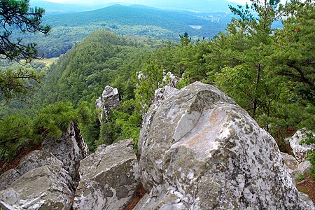
Monument Mountain is the name of a popular 503-acre (204 ha) open space reservation located in Great Barrington, Massachusetts on the southeast side of Monument Mountain. The reservation is centered on the 1,642 feet (500 m) subordinate summit of Peeskawso Peak. It is managed by The Trustees of Reservations, a non-profit conservation organization and is notable for its expansive views of the Housatonic River Valley, the Berkshires, the Taconic Mountains, and the Catskill Mountains of New York from the knife-edge summit of Peeskawso Peak. Monument Mountain, composed of erosion resistant quartzite, is of The Berkshires geology. The reservation receives more than 20,000 visitors a year. The mountain was logged for charcoal to fuel a furnace in Vandusenville at the corner of Division Street and Route 41 in Great Barrington. Remnants of the furnace can be seen if one stands on the Route 41 bridge and looks upstream on the Williams River.

Excerpt from the Wikipedia article Monument Mountain (reservation) (License: CC BY-SA 3.0, Authors, Images).

Monument Mountain (reservation)
Maple Street,

Geographical coordinates (GPS) Address Nearby Places
placeShow on map

Wikipedia: Monument Mountain (reservation)Continue reading on Wikipedia

Geographical coordinates (GPS)

Latitude Longitude
N 42.247333333333 ° E -73.340722222222 °
placeShow on map

Address

Monument Mountain Reservation

Maple Street
01236
Massachusetts, United States
mapOpen on Google Maps

Monument Mt.
Monument Mt.
Share experience

Nearby Places

Main Street Historic District (Stockbridge, Massachusetts)

The Main Street Historic District is a historic district encompassing the scenic and historic portions of Main Street in Stockbridge, Massachusetts. The downtown portion of Main Street is widely recognizable due to its use by Norman Rockwell in his 1967 painting, Main Street, Stockbridge at Christmas. The central portion of Main Street is a broad street with wide green lawns, anchored by a traditional New England town center containing a church and municipal buildings. Along this part of Main Street is the Mission House, a National Historic Landmark that is one of oldest buildings in Stockbridge, dating to the early 1740s. Further to the west the road is more rural, and the district's western boundary is at the crossing of Main Street over the Housatonic River. The eastern part of the district includes the retail heart of the town, including the Red Lion Inn and several blocks of shops. The far eastern part of the district is Laurel Hill, a wooded park with views of the town center. The district was added to the National Register of Historic Places in 2002.The Stockbridge area has a significant prehistory of Native American use, with archaeological evidence of human use on at least a seasonal basis dating back for centuries. In the early 18th century it was settled by Mahican Indians who had been driven from the Hudson River area by conflict with the Mohawks. These uses included the establishment of a Native burying ground, which is within the bounds of this district. In 1734, the Province of Massachusetts Bay founded a "Praying Indian" community, with its main settlement where the downtown area is now. The arrival of English squatters and conflicts over land usage patterns led to the Natives eventually losing control of the community. The area's colonial settlement accelerated after the end of the French and Indian War in 1763. The Red Lion Inn opened in 1775, and it flourished in the early 19th century as a crossroads community not far from the county seat at Lenox.