Bledsoe Creek State Park

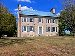
Bledsoe Creek State Park is a state park in Sumner County, Tennessee, in the southeastern United States. The park consists of 169 acres (0.68 km2) managed by the Tennessee Department of Environment and Conservation. The park spans much of the west shore of the Bledsoe Creek embayment of Old Hickory Lake, an impoundment of the Cumberland River created with the completion of Old Hickory Dam by the U.S. Army Corps of Engineers in 1954. Bledsoe Creek State Park was developed as a recreational area by the Corps as part of its Old Hickory Dam project, and was designated a state park by the state of Tennessee in 1973. The park is primarily a campground and recreational boating and fishing area, although the park has developed several miles of hiking trails and provides environmental programs throughout the year. The park is located within a 5-mile (8.0 km) radius of the Wynnewood and Cragfont state historic sites, Bledsoe's Fort Historic Park, a Mississippian-period mound complex, and the Cairo Rosenwald School, all of which attest to the area's pre-historic and historic importance to the Upper Cumberland region.
Excerpt from the Wikipedia article Bledsoe Creek State Park (License: CC BY-SA 3.0, Authors, Images).Bledsoe Creek State Park
Bledsoe Park Road,
Geographical coordinates (GPS) Address Nearby Places Show on map
 Continue reading on Wikipedia
 Geographical coordinates (GPS)
| Latitude | Longitude |
|---|---|
| N 36.37914 ° | E -86.35683 ° |
Address
Bledsoe Park Road 193
37066
Tennessee, United States
Open on Google Maps