Bledsoe's Station

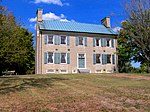
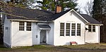
Bledsoe's Station, also known as Bledsoe's Fort, was an 18th-century fortified frontier settlement located in what is now Castalian Springs, Tennessee. The fort was built by longhunter and Sumner County pioneer Isaac Bledsoe (c. 1735–1793) in the early 1780s to protect Upper Cumberland settlers and migrants from hostile Native American attacks. While the fort is no longer standing, its location has been verified by archaeological excavations. The site is now part of Bledsoe's Fort Historical Park, a public park established in 1989 by Sumner County residents and Bledsoe's descendants. Bledsoe's Station was one of a series of frontier outposts built in the Upper Cumberland during the first major migration of Euro-American settlers into the Middle Tennessee area following the American Revolution. The fort was a convenient stopover along Avery's Trace—the main road connecting East and Middle Tennessee at the time. The flood of settlers into the region brought inevitable conflict with the region's Native American inhabitants, and dozens of settlers were killed in the late 1780s and early 1790s. Isaac Bledsoe's brother Anthony was killed in an ambush at the fort in 1788, and Isaac was killed while tending a field outside the fort in 1793. The end of the Cherokee–American wars in 1794 ended much of the violence in the region and reduced the fort's necessity. Bledsoe's Fort Historical Park protects the fort's excavation site, as an outline of the fort's walls can be discerned from former excavation trenches, as well as several historic structures, including the Nathaniel Parker Cabin and Hugh Rogan Cottage, who were compatriots of Isaac Bledsoe and a pioneer cemetery, with a large obelisk, dedicated to the Bledsoe brothers. The Castalian Springs Mound Site and the Wynnewood State Historic Site are located immediately east of the park, and the Cragfont State Historic Site is located immediately to the west.
Excerpt from the Wikipedia article Bledsoe's Station (License: CC BY-SA 3.0, Authors, Images).Bledsoe's Station
Hartsville Pike,
Geographical coordinates (GPS) Address Nearby Places Show on map
 Continue reading on Wikipedia
 Geographical coordinates (GPS)
| Latitude | Longitude |
|---|---|
| N 36.399444444444 ° | E -86.320555555556 ° |
Address
Hartsville Pike
Hartsville Pike
37031
Tennessee, United States
Open on Google Maps