place

Gallatin Fossil Plant

1956 establishments in TennesseeBuildings and structures in Sumner County, TennesseeCoal-fired power stations in TennesseeEnergy infrastructure completed in 1956Energy infrastructure completed in 1957
Energy infrastructure completed in 1959Energy infrastructure completed in 1975Energy infrastructure completed in 2000Tennessee Valley AuthorityUnited States power station stubs
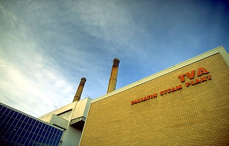
Gallatin fossil plant

The Gallatin Fossil Plant is a coal and natural gas-fired power plant near Gallatin, Tennessee operated by the Tennessee Valley Authority (TVA). The plant was originally entirely a coal-fired plant, constructed in the 1950s, and natural gas units were added later.

Excerpt from the Wikipedia article Gallatin Fossil Plant (License: CC BY-SA 3.0, Authors, Images).

Gallatin Fossil Plant
Steam Plant Road,

Geographical coordinates (GPS) Address Nearby Places
placeShow on map

Wikipedia: Gallatin Fossil PlantContinue reading on Wikipedia

Geographical coordinates (GPS)

Latitude Longitude
N 36.314722222222 ° E -86.400277777778 °
placeShow on map

Address

Steam Plant Road 1457
37066
Tennessee, United States
mapOpen on Google Maps

Gallatin fossil plant
Share experience

Nearby Places

Cairo Rosenwald School

Cairo Rosenwald School is a former school for African-American children located in the unincorporated community of Cairo, Sumner County, Tennessee. It was one of seven Rosenwald schools built in the county.Construction of the school began in 1922 and was completed in 1923. The Julius Rosenwald Fund provided $500 toward the construction cost, the African-American community of Cairo raised $700 toward the project cost, and the Tennessee public school fund provided the remaining $700.The school was built according to a standard design for a one-teacher Rosenwald school. Built on a stone foundation, it has a gable-end entrance and weatherboard siding. Its interior contains one classroom, with two cloak closets on either side of the entrance door and a platform across the end of the building opposite the door. Modernization efforts after World War II included addition of electric wiring and indoor plumbing, resulting in one of the cloak closets being converted to a restroom.The school was operated until 1959, serving grades 1 through 8. After it closed due to school consolidation, it became a community center. In 1996, it was listed on the National Register of Historic Places due to efforts by the Cairo Improvement Club. The building underwent a major restoration in 2008–2009 under the direction of the Tennessee Preservation Trust and the Middle Tennessee State University Center for Historic Preservation. The restoration project was assisted by a grant award of $46,987 from Lowe's Charitable and Educational Foundation.

Old Hickory Lake
Old Hickory Lake

Old Hickory Lake is a reservoir in north central Tennessee. It is formed by the Old Hickory Lock and Dam (36°17′48″N 86°39′20″W), located on the Cumberland River at mile 216.2 in Sumner and Davidson counties, approximately 25 miles (40 km) upstream from Nashville. The city of Hendersonville is situated on the northern shoreline of the lake, and Old Hickory, a portion of Metropolitan Nashville-Davidson County, is located on the southern side of the lake, just upstream of the lock and dam. The lake extends 97.3 miles (156.6 km) upstream to Cordell Hull Lock and Dam (36°17′25″N 85°56′36″W), near Carthage, Tennessee. The dam and lake are named after President Andrew Jackson (nicknamed "Old Hickory"), who lived in the vicinity, at The Hermitage. The lock, dam, powerhouse and lake are operated and supervised by U.S. Army Corps of Engineers staff under the direction of the District Engineer at Nashville. Construction started in January 1952, and dam closure was completed in June 1954. Historic Rock Castle, completed in 1796, is the former home of pioneer Daniel Smith. He is known for his contributions in settling Hendersonville in the early nineteenth century. The lake now borders this property. Old Hickory Lake is a mainstream storage impoundment on the Cumberland River operated by the U.S. Army Corps of Engineers. The reservoir contains 22,500 acres (91 km2) at an elevation of 445 feet (above sea level) and extends 97.3 river miles. Water level fluctuations are minimal with minimum pool elevation at 442 feet (135 m). Public facilities include eight marinas, two Corps-operated campgrounds, and 41 boat access sites, as well as the Old Hickory Lake Arboretum.