Clos du Doubs

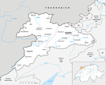
Clos du Doubs (Franc-Comtois: Chôs di Doubs) is a municipality in the district of Porrentruy in the canton of Jura in Switzerland. It was founded on 1 January 2009 by the former municipalities of Epauvillers, Epiquerez, Montenol, Montmelon, Ocourt, Saint-Ursanne and Seleute. Soubey voted not to join the merger. Clos du Doubs can also refer to a range of the Jura folds south-west of Saint-Ursanne. The new municipality took its name from this regional designation (which also includes Soubey). The region includes the section of the Doubs valley near Saint-Ursanne, about 15 km (9.3 mi) west of Delémont. The region covers about 80 km2 (31 sq mi), centered on the village of Saint-Ursanne.
Excerpt from the Wikipedia article Clos du Doubs (License: CC BY-SA 3.0, Authors, Images).Clos du Doubs
Route Cantonale, Clos du Doubs
Geographical coordinates (GPS) Address Nearby Places Show on map
Geographical coordinates (GPS)
| Latitude | Longitude |
|---|---|
| N 47.35 ° | E 7.15 ° |
Address
Route Cantonale
Route Cantonale
2884 Clos du Doubs
Jura, Switzerland
Open on Google Maps


