place

Brandish Corner

Corners of the Isle of Man TTIsle of Man stubsRoads in the Isle of ManUse British English from December 2016
Brandish geograph.org.uk 469521

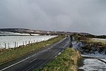
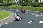
Brandish Corner (formerly known as Upper-Hillberry Corner and previously Telegraph Hill) is situated between the 35th and 36th Milestone road-side markers on the Snaefell Mountain Course on the primary A18 Mountain Road in the parish of Onchan in the Isle of Man. The road was re-engineered in recent years. Brandish Corner was part of the Highland Course and Four Inch Course used for the Gordon Bennett Trial and Tourist Trophy car races held between 1904 and 1922. Brandish Corner is part of the Snaefell Mountain Course used since 1911 for the Isle of Man TT and Manx Grand Prix races.This part of the Mountain Course was named Brandish Corner after Walter Brandish who crashed in the right-hand gutter while trying to pass another competitor at Upper Hilberry Corner, between Creg-ny-Baa and Hillberry Corner, and broke a leg during practice for the 1923 Isle of Man TT Races.During the winter of 2005/2006 road widening occurred at Windy Corner followed by Brandish Corner during the autumn of 2006 by the Isle of Man Department of Transport, due to collision figures at both locations involving local, two-way traffic.

Excerpt from the Wikipedia article Brandish Corner (License: CC BY-SA 3.0, Authors, Images).

Brandish Corner
Mountain Road,

Geographical coordinates (GPS) Address Nearby Places
placeShow on map

Wikipedia: Brandish CornerContinue reading on Wikipedia

Geographical coordinates (GPS)

Latitude Longitude
N 54.195555555556 ° E -4.4777777777778 °
placeShow on map

Address

Mountain Road

Mountain Road

Isle of Man
mapOpen on Google Maps

Brandish geograph.org.uk 469521
Share experience

Nearby Places

The Nook, Isle of Man

The Nook (Middle English: a corner or recess) is situated on the primary A18 Mountain Road in the parish of Onchan in the Isle of Man between the 37th Milestone road-side marker on the Snaefell Mountain Course and the TT Grandstand on the primary A2 Glencrutchery Road in the town of Douglas. The Nook along with the nearby Governor's Bridge road junction and hairpin bends is part of the Snaefell Mountain Course used since 1920 for the Isle of Man TT and from 1923 for the Manx Grand Prix Races. The Nook was part of the Clypse Course for the Isle of Man TT races between 1954 and 1959. It is also part of the Willaston Circuit used for cycle racing, classic car racing and used as part of timed special stage for the Rally Isle of Man. For the 1954 Isle of Man TT races, the approach to Governor's Bridge including The Nook corner on the A18 Bemahauge Road was widened to accommodate the re-introduced Sidecar TT on the Clypse Course. The Department of Transport announced a proposal to build a new section of road for the Mountain Course with a link road from The Nook to Governor's Bridge using parts of the pre-existing A18 Bemahague Road. This road widening scheme occurred between February and April 2008 with the removal of trees on the Bemahague Estate which includes Government House, the official residence of the Lieutenant Governor of the Isle of Man. The Isle of Man TT Races and Manx Grand Prix continued to use the original A18 Bemahauge Road that runs parallel to the new link road from The Nook to the Governor's Dip for motor-cycle racing.