place

Hillberry Corner

Corners of the Isle of Man TTIsle of Man stubsRoads in the Isle of ManUse British English from October 2017
Hillberry geograph.org.uk 469513

Hillberry Corner (in Manx: Knock berrey or Cronkybury) is situated at the 36th Milestone road-side marker on the Snaefell Mountain Course, being on the primary A18 Mountain Road with the side-road junction of the C22 Little Mill Road, in the parish of Onchan in the Isle of Man. Hillberry Corner was part of the Highland Course and Four Inch Course used for the Gordon Bennett Trial and Tourist Trophy car races between 1904 and 1922. For the 1908 Tourist Trophy race for cars, the startline was moved from the road junction of the A2 Quarterbridge Road/Alexander Drive to Hillberry Corner as part of the new Four Inch Course. A small iron-framed grandstand was built for spectators and still remains at the site. Hillberry Corner is part of the Mountain Course used since 1911 for the Isle of Man TT and Manx Grand Prix races. To facilitate racing on the Clypse Course for the 1954 TT races during the winter of 1953/54 road widening occurred on the Mountain Course at Creg-ny-Baa, Signpost Corner, the section of road from Hillberry Corner to Cronk-ny-Mona, and the approach to Governor's Bridge.

Excerpt from the Wikipedia article Hillberry Corner (License: CC BY-SA 3.0, Authors, Images).

Geographical coordinates (GPS)

Latitude Longitude
N 54.187777777778 ° E -4.4755555555556 °
placeShow on map

Address

A18

Isle of Man
mapOpen on Google Maps

Hillberry geograph.org.uk 469513
Share experience

Nearby Places

The Nook, Isle of Man

The Nook (Middle English: a corner or recess) is situated on the primary A18 Mountain Road in the parish of Onchan in the Isle of Man between the 37th Milestone road-side marker on the Snaefell Mountain Course and the TT Grandstand on the primary A2 Glencrutchery Road in the town of Douglas. The Nook along with the nearby Governor's Bridge road junction and hairpin bends is part of the Snaefell Mountain Course used since 1920 for the Isle of Man TT and from 1923 for the Manx Grand Prix Races. The Nook was part of the Clypse Course for the Isle of Man TT races between 1954 and 1959. It is also part of the Willaston Circuit used for cycle racing, classic car racing and used as part of timed special stage for the Rally Isle of Man. For the 1954 Isle of Man TT races, the approach to Governor's Bridge including The Nook corner on the A18 Bemahauge Road was widened to accommodate the re-introduced Sidecar TT on the Clypse Course. The Department of Transport announced a proposal to build a new section of road for the Mountain Course with a link road from The Nook to Governor's Bridge using parts of the pre-existing A18 Bemahague Road. This road widening scheme occurred between February and April 2008 with the removal of trees on the Bemahague Estate which includes Government House, the official residence of the Lieutenant Governor of the Isle of Man. The Isle of Man TT Races and Manx Grand Prix continued to use the original A18 Bemahauge Road that runs parallel to the new link road from The Nook to the Governor's Dip for motor-cycle racing.

Governor's Bridge (Isle of Man)

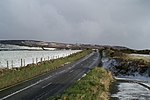
Governor's Bridge (formerly known as Heywood's Bridge or the Deemster's Bridge) is a hairpin bend adjacent to a road junction on the primary A18 Mountain Road in the parish of Onchan in the Isle of Man, with a sudden drop in elevation leading to Governor's Dip, followed by a left-hand bend and finally a right exiting on to the main Glencrutchery Road. 
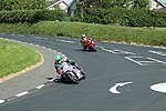
The Governor's Bridge road junction and hairpin bend are part of the Snaefell Mountain Course used since 1920 for the Isle of Man TT and from 1923 for the Manx Grand Prix Races. This junction was part of the Clypse Course for the TT races between 1954 and 1959. It is also part of the Willaston Circuit used for cycle racing, classic car racing and used as part of a timed special stage for the Rally Isle of Man. For the 1920 Isle of Man TT Races, changes were made to the Mountain Course and competitors then turned left at Hillberry, continuing uphill at Cronk-ny-Mona following the primary A18 Mountain Road to Governor's Bridge, with a new start/finish line on Glencrutchery Road which lengthened the course to 37¾ miles. This included the creation of a new link road at Governor's Bridge on the primary A2 Ramsey to Douglas Road between the road junction of the newly created A18 Bemahague road (from Governor's Bridge to Signpost Corner), the A2 Governor's Road/Glencrutchery Road and Victoria Road in Douglas. The new A2 link road effectively redirected the main road traffic and created the Governor's Dip bends off the primary A2 road which was used as part of the Snaefell Mountain Course for motor-cycle racing. The new link road also created a small wooded glen on the site which is known for its distinctive horse-chestnut trees. For the 1954 Isle of Man TT races, the approach to Governor's Bridge on the A18 Bemahague Road was widened with the removal of a grass bank to facilitate turning of the wider sidecar outfits in the re-introduced Sidecar TT on the Clypse Course. During October 2007 the Isle of Man Department of Transport began road widening at Braddan Bridge, further around the Mountain Course exiting Douglas, additionally creating a roundabout. The Department of Transport also announced a proposal to build a new section of road for the Mountain Course with a link road from Signpost Corner to Governor's Bridge using the pre-existing A18 Bemahague Road. This road widening scheme occurred between February and April 2008, with the removal of trees on the Bemahague Estate (which includes Government House, the official residence of the Lieutenant Governor of the Isle of Man) and the creation of a small mini-roundabout. Further work by the Isle of Man Department of Transport in July and September 2008 included the installation of a storm drain and the completion of the mini-roundabout. The Isle of Man TT Races and Manx Grand Prix continue to use the original A18 Bemahague Road (designated as Old Bemahague Road which runs parallel to the new link road) and the Governor's Dip for motorcycle racing, avoiding the new road sections.