Sieg

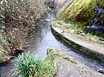
The Sieg is a river in North Rhine-Westphalia and Rhineland-Palatinate, Germany. It is a right tributary of the Rhine. The river is named after the Sicambri. It is 155 kilometres (96 mi) in length. The source is located in the Rothaargebirge mountains. From here the river runs southwestwards to the city of Siegen and the hills of Siegerland, both named after the river. Further west the Sieg valley forms the boundary of the Bergisches Land (northern) and Westerwald (southern). The river finally runs through a protected area east of the city of Bonn. After passing the cities of Hennef and Siegburg, the river flows into the Rhine at the Naturschutzgebiet Siegaue, a protected area immediately to the northeast of the city of Bonn, near Niederkassel/Mondorf.
Excerpt from the Wikipedia article Sieg (License: CC BY-SA 3.0, Authors, Images).Sieg
Hafenstraße,
Geographical coordinates (GPS) Address Nearby Places Show on map
Geographical coordinates (GPS)
| Latitude | Longitude |
|---|---|
| N 50.768611111111 ° | E 7.0755555555556 ° |
Address
Sieghöhenweg
Hafenstraße
53859 , Mondorf
North Rhine-Westphalia, Germany
Open on Google Maps


