Kemper Werth
History of BonnLandforms of North Rhine-WestphaliaPeninsulas of Germany
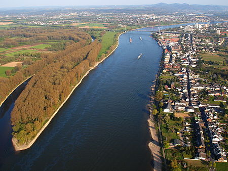
The Kemper Werth (also known as auf dem Schänzchen and historically as the Pfaffenmütze) is a promontory in the Rhine at the mouth of the River Sieg, in the northeast of Bonn, in Germany. Formerly a pair of islands, it became attached to the river bank as a result of engineering work altering the confluence of the Sieg. It was the site of a fort during the Eighty Years' War and is now part of a protected natural area, the Naturschutzgebiet Siegaue.
Excerpt from the Wikipedia article Kemper Werth (License: CC BY-SA 3.0, Authors, Images).Kemper Werth
Estermannufer, Bonn Graurheindorf (Stadtbezirk Bonn)
Geographical coordinates (GPS) Address Nearby Places Show on map
Geographical coordinates (GPS)
| Latitude | Longitude |
|---|---|
| N 50.764722222222 ° | E 7.0861111111111 ° |
Address
Estermannufer
Estermannufer
53117 Bonn, Graurheindorf (Stadtbezirk Bonn)
North Rhine-Westphalia, Germany
Open on Google Maps
