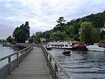
Handbuck Eyot
Berkshire geography stubsIslands of BerkshireIslands of OxfordshireIslands of the River ThamesOxfordshire geography stubs ... and 1 more
Use British English from June 2017

Handbuck Eyot or Handbuck Ait is a thin, wooded island in the River Thames in England towards the eastern edge of the villages of Shiplake, Oxfordshire. It is on the reach above Marsh Lock.
Excerpt from the Wikipedia article Handbuck Eyot (License: CC BY-SA 3.0, Authors, Images).Handbuck Eyot
Bolney Road, South Oxfordshire
Geographical coordinates (GPS) Address Nearby Places Show on map
Geographical coordinates (GPS)
| Latitude | Longitude |
|---|---|
| N 51.5154 ° | E -0.8808 ° |
Address
Bolney Road
RG9 3NT South Oxfordshire
England, United Kingdom
Open on Google Maps


